NWS National Hurricane Center Miami FL AL062021
500 PM AST Mon Aug 09 2021
...DISTURBANCE APPROACHING THE LESSER ANTILLES FORECAST TO BECOME A TROPICAL STORM TONIGHT...
...TROPICAL STORM WATCHES ISSUED...
SUMMARY OF 500 PM AST...2100 UTC...INFORMATION
----------------------------------------------
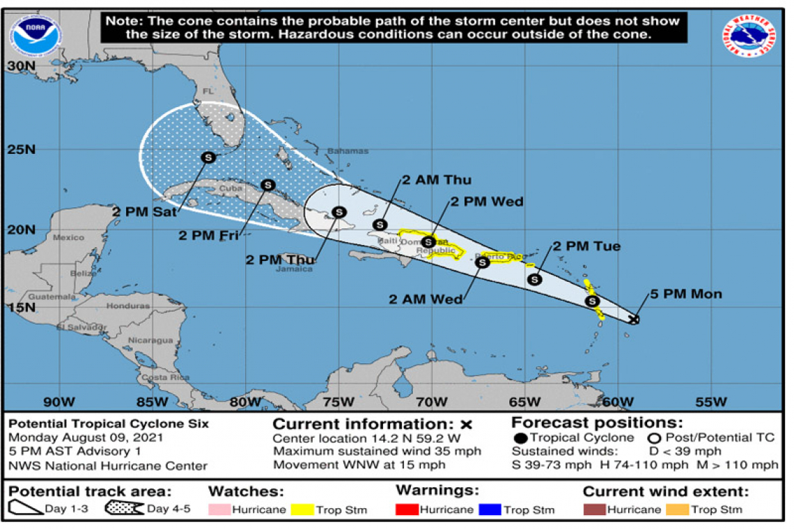
LOCATION...14.2N 59.2W
ABOUT 165 MI...260 KM ESE OF DOMINICA
ABOUT 205 MI...330 KM SE OF GUADELOUPE
MAXIMUM SUSTAINED WINDS...35 MPH...55 KM/H
PRESENT MOVEMENT...WNW OR 290 DEGREES AT 15 MPH...24 KM/H
MINIMUM CENTRAL PRESSURE...1010 MB...29.83 INCHES
WATCHES AND WARNINGS
--------------------
CHANGES WITH THIS ADVISORY:
The government of France has been issued a Tropical Storm Watch for Guadeloupe and Martinique.
The government of Barbados has been issued a Tropical Storm Watch for Dominica.
The government of the Dominican Republic has issued a Tropical Storm Watch for the Dominican Republic from Punta Palenque eastward along the southern coast of the island and the entire northern coast to the Dominican Republic/Haiti border.
A Tropical Storm Watch has been issued for the U.S. Virgin Islands and Puerto Rico, including Culebra and Vieques.
SUMMARY OF WATCHES AND WARNINGS IN EFFECT:
A Tropical Storm Watch is in effect for...
* Martinique and Guadeloupe
* Dominica
* Puerto Rico, including Culebra and Vieques
* U.S. Virgin Islands
* Dominican Republic on the south coast from Punta Palenque eastward and the entire northern coast to the Dominican Republic/Haiti border.
A Tropical Storm Watch means that tropical storm conditions are possible within the watch area.
For storm information specific to your area, please monitor products issued by your national meteorological service.
DISCUSSION AND OUTLOOK
----------------------
At 500 PM AST (2100 UTC), the disturbance was centered near latitude 14.2 North, longitude 59.2 West. The system is moving toward the west-northwest near 15 mph (24 km/h) and this general motion is expected to continue during the next few days. On the forecast track, the system is expected to move through a portion of the southern Leeward Islands tonight, pass near or over the U.S. Virgin Islands and Puerto Rico late Tuesday and Tuesday night, and near or over Hispaniola on Wednesday.
Maximum sustained winds are near 35 mph (55 km/h) with higher gusts. Gradual strengthening is forecast during the next 48 hours and the disturbance is expected to become a tropical storm tonight.
* Formation chance through 48 hours...high...80 percent.
* Formation chance through 5 days...high...80 percent.
The estimated minimum central pressure is 1010 mb (29.83 inches).
HAZARDS AFFECTING LAND
----------------------
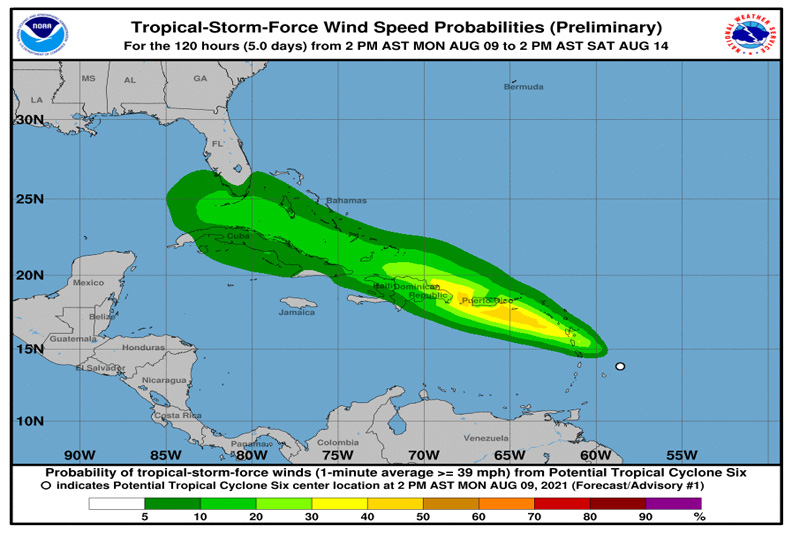
RAINFALL: The potential tropical cyclone is expected to produce the following rainfall amounts:
Over the Leeward Islands, Virgin Islands, and Puerto Rico...2 to 4 inches, with isolated amounts of 6 inches. This rainfall could lead to flash, urban, and small stream flooding and potential mudslides across the U.S. Virgin Islands and Puerto Rico.
Over the northern Windward Islands...1 to 3 inches.
Over the Dominican Republic...3 to 6 inches.
WIND: Tropical storm conditions are possible within the watch area in the Lesser Antilles tonight, and are also possible within the watch area in the U.S. Virgin Islands and Puerto Rico beginning Tuesday afternoon. Tropical storm conditions are possible within the watch area in the Dominican Republic beginning early Wednesday.