
...TROPICAL STORM EXPECTED TO PASS NORTH OF THE LEEWARD ISLANDS EARLY THIS WEEK...
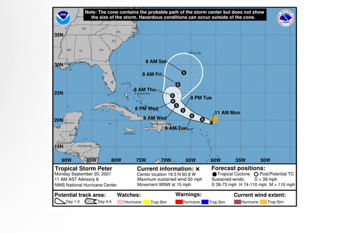
Tropical Storm Peter Advisory Number 8
NWS National Hurricane Center Miami FL AL162021
1100 AM AST Mon Sep 20 2021
SUMMARY OF 1100 AM AST...1500 UTC...INFORMATION
-----------------------------------------------
LOCATION...19.5N 60.9W
ABOUT 170 MI...275 KM ENE OF THE NORTHERN LEEWARD ISLANDS
MAXIMUM SUSTAINED WINDS...50 MPH...85 KM/H
PRESENT MOVEMENT...WNW OR 290 DEGREES AT 15 MPH...24 KM/H
MINIMUM CENTRAL PRESSURE...1007 MB...29.74 INCHES
WATCHES AND WARNINGS
--------------------
 There are no coastal watches or warnings in effect.
Interests in the northern Leeward Islands, Virgin Islands, and Puerto Rico should monitor the progress of this system.
DISCUSSION AND OUTLOOK
----------------------
At 1100 AM AST (1500 UTC), the center of Tropical Storm Peter was located near latitude 19.5 North, longitude 60.9 West. Peter is moving toward the west-northwest near 15 mph (24 km/h). This general motion is expected to continue during the next couple of days, followed by a turn to the northwest with a decrease in forward speed on Wednesday. On the forecast track, the center of Peter will pass north of the northern Leeward Islands and Puerto Rico through Tuesday.
Data from an Air Force Reserve Hurricane Hunter aircraft indicate that the maximum sustained remain near 50 mph (85 km/h) with higher gusts. Slow weakening is forecast during the next few days.
Tropical-storm-force winds extend outward up to 125 miles (205 km) from the center.
The estimated minimum central pressure based on aircraft data is 1007 mb (29.74 inches).
HAZARDS AFFECTING LAND
----------------------
RAINFALL: Rainfall around the southern periphery of Tropical Storm Peter could produce rainfall totals of 1 to 3 inches, with locally higher amounts possible, across portions of the Northern Leeward Islands, including the Virgin Islands, as well as Puerto Rico and the northern portions of Hispaniola through Tuesday. This rainfall may lead to areas of urban and small stream flooding.
SURF: Swells generated by Peter are expected to affect the northern Leeward Islands early this week, and then reach the Bahamas by midweek. These swells could cause life-threatening surf and rip current conditions. Please consult products from your local weather office.
Forecaster Latto


