
Potential Tropical Cyclone Nine Advisory Number 6
NWS National Hurricane Center Miami FL AL092020
500 PM AST Wed Jul 29 2020
MDS Special Weather Bulletin 29 Jul 2020 no. 8.pdf
SUMMARY OF 500 PM AST...2100 UTC...INFORMATION
----------------------------------------------
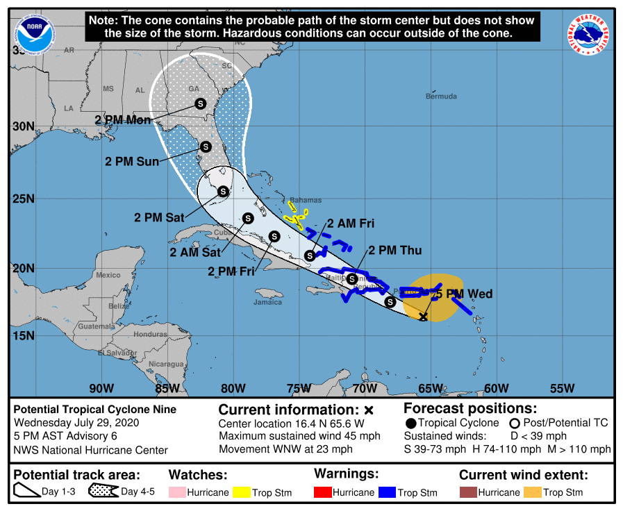
LOCATION...16.4N 65.6W
ABOUT 105 MI...170 KM SSW OF ST. CROIX
ABOUT 320 MI...510 KM ESE OF SANTO DOMINGO DOMINICAN REPUBLIC
MAXIMUM SUSTAINED WINDS...45 MPH...75 KM/H
PRESENT MOVEMENT...WNW OR 290 DEGREES AT 23 MPH...37 KM/H
MINIMUM CENTRAL PRESSURE...1004 MB...29.65 INCHES
WATCHES AND WARNINGS
--------------------
CHANGES WITH THIS ADVISORY:
The government of Antigua has discontinued the Tropical Storm Warning for Montserrat, St. Kitts, and Nevis.
SUMMARY OF WATCHES AND WARNINGS IN EFFECT:
A Tropical Storm Warning is in effect for...
* Puerto Rico, Vieques, Culebra
* U.S. Virgin Islands
* British Virgin Islands
* Anguilla
* St. Martin and St. Barthelemy
* Saba and St. Eustatius
* St. Maarten
* Dominican Republic entire southern and northern coastlines
* North coast of Haiti from Le Mole St Nicholas eastward to the northern border with the Dominican Republic
* Turks and Caicos Islands
* Southeastern Bahamas including the Acklins, Crooked Island, Long Cay, the Inaguas, Mayaguana, and the Ragged Islands
A Tropical Storm Watch is in effect for...
* Central Bahamas, including Cat Island, the Exumas, Long Island, Rum Cay, and San Salvador
Interests in the northwestern Bahamas and Cuba should monitor the progress of this system.
DISCUSSION AND OUTLOOK
----------------------
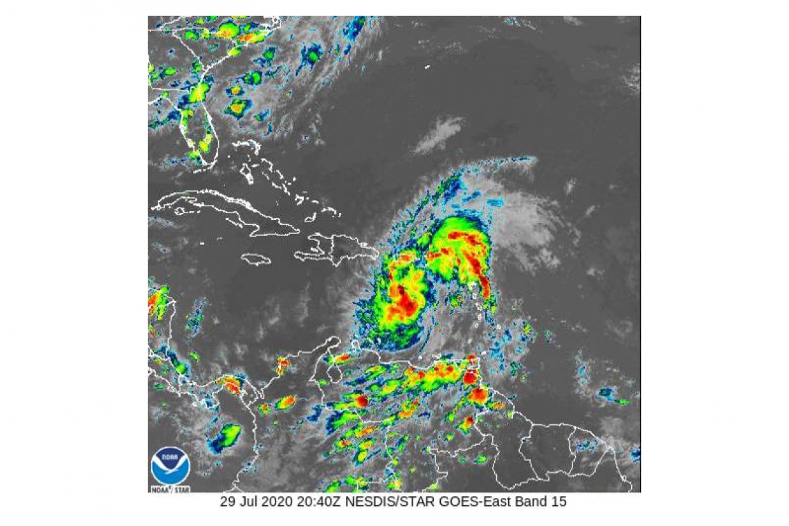
At 500 PM AST (2100 UTC), the disturbance was centered near latitude 16.4 North, longitude 65.6 West. The system is moving toward the west-northwest near 23 mph (37 km/h), and this general motion with a reduction in forward speed is expected over the next few days. On the forecast track, the system will pass south of Puerto Rico later tonight, near or over Hispaniola on Thursday, near eastern Cuba
and the southeastern Bahamas on Friday, and approach the northwestern Bahamas and southern Florida Friday night.
Maximum sustained winds are near 45 mph (75 km/h) with higher gusts. Some increase in strength is forecast through tonight, with weakening likely on Thursday due to land interaction. Some restrengthening is possible by this weekend.
Environmental conditions are expected to be conducive for additional development, and a tropical storm is forecast to form tonight.
* Formation chance through 48 hours...high...90 percent
* Formation chance through 5 days...high...90 percent
Tropical-storm-force winds extend outward up to 275 miles (445 km)
primarily to the north of the center. A wind gust of 52 mph (83
km/h) was recently reported at St. Thomas in the U.S. Virgin
Islands.
The estimated minimum central pressure is 1004 mb (29.65 inches).
HAZARDS AFFECTING LAND
----------------------
WIND: Tropical storm conditions will continue across portions of the Leeward Islands, the U.S. and British Virgin Islands and Puerto Rico through tonight. These conditions are forecast to reach portions of the Dominican Republic and Haiti within the warning area by late tonight or early Thursday, and the southeastern Bahamas and Turks and Caicos Thursday afternoon. Tropical storm conditions are possible in the watch area on Friday.
RAINFALL: The disturbance is expected to produce the following rain accumulations:
Across the northern Leeward Islands, British and U.S. Virgin Islands: 3 to 6 inches.
Across Puerto Rico: 3 to 6 inches, with isolated maximum totals of 10 inches.
Across the Dominican Republic, northern Haiti, and Turks and Caicos: 3 to 6 inches, with isolated maximum totals of 8 inches.
Across the Inagua Islands and southeastern Bahamas: 4 to 8 inches.
These rainfall amounts may lead to life-threatening flash flooding and mudslides, as well as potential riverine flooding beginning today. Urban and small stream flooding is expected for the U.S. Virgin Islands and eastern Puerto Rico.
SURF: Swells generated by Potential Tropical Cyclone Nine will be affecting portions of the Leeward Islands, the Virgin Islands and Puerto Rico through Thursday. These swells are forecast to reach the north coast of the Dominican Republic, the Turks and Caicos Islands and the southeastern Bahamas tonight or Thursday. These swells are likely to cause life-threatening surf and rip current conditions. Please consult products from your local weather office.


