
Potential Tropical Cyclone Nine Intermediate Advisory Number 4A
NWS National Hurricane Center Miami FL AL092020
800 AM AST Wed Jul 29 2020
SUMMARY OF 800 AM AST...1200 UTC...INFORMATION
----------------------------------------------
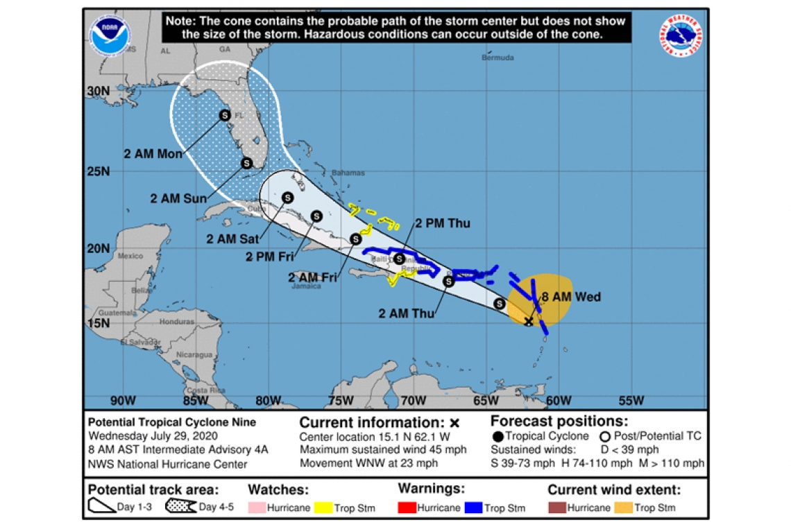
LOCATION...15.1N 62.1W
ABOUT 55 MI...90 KM WSW OF DOMINICA
ABOUT 350 MI...560 KM SE OF SAN JUAN PUERTO RICO
MAXIMUM SUSTAINED WINDS...45 MPH...75 KM/H
PRESENT MOVEMENT...WNW OR 290 DEGREES AT 23 MPH...37 KM/H
MINIMUM CENTRAL PRESSURE...1005 MB...29.68 INCHES
WATCHES AND WARNINGS
--------------------
CHANGES WITH THIS ADVISORY:
The government of Barbados has discontinued the Tropical Storm Warning for Dominica.
SUMMARY OF WATCHES AND WARNINGS IN EFFECT:
A Tropical Storm Warning is in effect for...
* Puerto Rico, Vieques, Culebra
* U.S. Virgin Islands
* British Virgin Islands
* Antigua, Barbuda, Montserrat, St. Kitts, Nevis, and Anguilla
* Guadeloupe, Martinique, St. Martin, and St. Barthelemy
* Saba and St. Eustatius
* St. Maarten
* Dominican Republic from Cabo Caucedo eastward to Cabo Engano and then westward along the northern coast to the Dominican Republic/Haiti border
* North coast of Haiti from Le Mole St Nicholas eastward to the northern border with the Dominican Republic
A Tropical Storm Watch is in effect for...
* Dominican Republic from the southern Haiti border eastward to Cabo Caucedo
* Turks and Caicos Islands
* Southeastern Bahamas
Interests in the central and northwestern Bahamas and Cuba should
monitor the progress of this system.
A Tropical Storm Warning means that tropical storm conditions are expected somewhere within the warning area within 36 hours.
A Tropical Storm Watch means that tropical storm conditions are possible within the watch area, generally within 48 hours.
DISCUSSION AND OUTLOOK
----------------------
At 800 AM AST (1200 UTC), the disturbance was centered near latitude 15.1 North, longitude 62.1 West. The system is moving toward the west-northwest near 23 mph (37 km/h), and this general motion with some reduction in forward speed is expected over the next few days. On the forecast track, the system will move near or over Puerto Rico tonight, near or over Hispaniola on Thursday, and near or over the southeastern Bahamas on Friday.
Maximum sustained winds remain near 45 mph (75 km/h) with higher gusts. Some increase in strength is forecast today, with weakening likely on Thursday due to land interaction, and some restrengthening possible late week.
Environmental conditions are expected to be conducive for additional development, and a tropical storm is forecast to form later today.
* Formation chance through 48 hours...high...90 percent
* Formation chance through 5 days...high...90 percent
Tropical-storm-force winds extend outward up to 275 miles (445 km) primarily to the north and northeast of the center. A wind gust of 46 mph (74 km/h) was recently reported on St. Kitts.
The estimated minimum central pressure is 1005 mb (29.68 inches).
HAZARDS AFFECTING LAND
----------------------
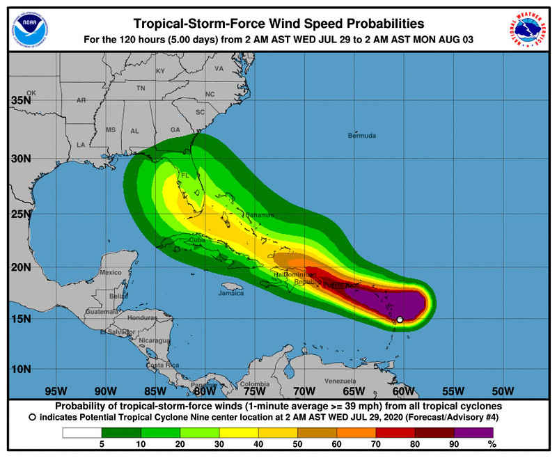
WIND: Tropical storm conditions are moving across portions of the Leeward Islands and will spread across the U.S. and British Virgin Islands and Puerto Rico this afternoon through Thursday morning. These conditions are forecast to reach portions of the Dominican Republic and Haiti within the warning area early Thursday. Tropical storm conditions are possible in the watch areas on Thursday.
RAINFALL: The potential tropical cyclone is expected to produce the following rain accumulations:
Across the northern Leeward Islands, British and U.S. Virgin Islands: 3 to 6 inches.
Across Puerto Rico: 3 to 6 inches, with isolated maximum totals of 10 inches.
Across the Dominican Republic, northern Haiti and the Turks and Caicos: 3 to 6 inches, with isolated maximum totals of 8 inches.
Across the Inagua Islands: 4 to 8 inches, with isolated totals of 12 inches.
These rainfall amounts could lead to life threatening flash flooding and mudslides, as well as potential riverine flooding.
SURF: Swells generated by Potential Tropical Cyclone Nine will be affecting portions of the Leeward Islands, the Virgin Islands and Puerto Rico during the next day or two. These swells are forecast to reach the north coast of the Dominican Republic and the Turks and Caicos Islands and the southeastern Bahamas on Thursday. These swells are likely to cause life-threatening surf and rip current conditions. Please consult products from your local weather office.
Forecaster Brown


