...NOAA HURRICANE HUNTERS FIND HANNA A LITTLE FARTHER NORTH...
NWS National Hurricane Center Miami FL AL082020
700 AM CDT Fri Jul 24 2020
SUMMARY OF 700 AM CDT...1200 UTC...INFORMATION
----------------------------------------------
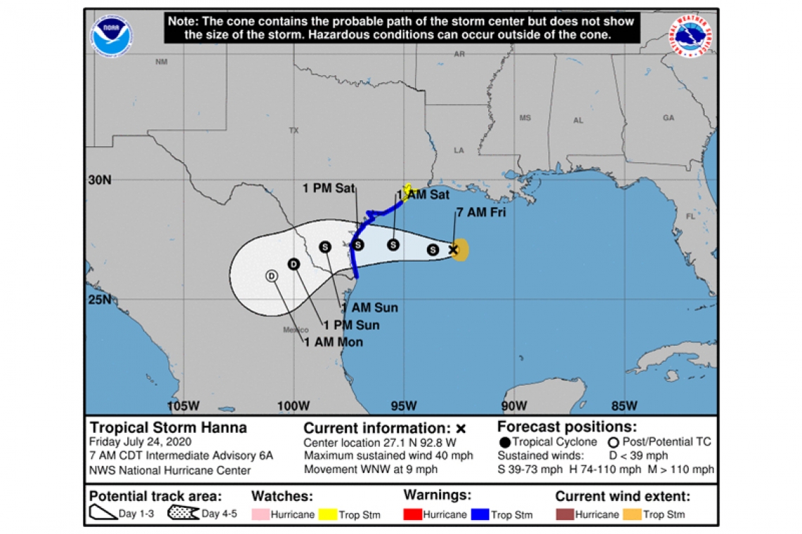
LOCATION...27.1N 92.8W
ABOUT 285 MI...460 KM E OF CORPUS CHRISTI TEXAS
MAXIMUM SUSTAINED WINDS...40 MPH...65 KM/H
PRESENT MOVEMENT...WNW OR 290 DEGREES AT 9 MPH...15 KM/H
MINIMUM CENTRAL PRESSURE...1001 MB...29.56 INCHES
WATCHES AND WARNINGS
--------------------
CHANGES WITH THIS ADVISORY:
None.
SUMMARY OF WATCHES AND WARNINGS IN EFFECT:
A Tropical Storm Warning is in effect for...
* Mouth of the Rio Grande to San Luis Pass Texas
A Tropical Storm Watch is in effect for...
* San Luis Pass to High Island Texas
A Tropical Storm Warning means that tropical storm conditions are expected somewhere within the warning area within 36 hours.
A Tropical Storm Watch means that tropical storm conditions are possible within the watch area, generally within 48 hours.
Interests along the Texas and Louisiana coast should monitor the progress of this system.
For storm information specific to your area, including possible inland watches and warnings, please monitor products issued by your local National Weather Service forecast office.
DISCUSSION AND OUTLOOK
----------------------
At 700 AM CDT (1200 UTC), the center of Tropical Storm Hanna was located by a NOAA reconnaissance aircraft near latitude 27.1 North, longitude 92.8 West. Hanna is moving toward the west-northwest near 9 mph (15 km/h) and a turn toward the west is expected tonight,followed by a generally westward motion through the weekend. On the forecast track, the storm center should make landfall along the Texas coast within the warning area on Saturday.
Maximum sustained winds are near 40 mph (65 km/h) with higher gusts. Gradual strengthening is expected until the tropical cyclone makes landfall. Steady weakening is expected after Hanna moves inland.
Tropical-storm-force winds extend outward up to 45 miles (75 km) from the center. During the past few hours, a buoy located east of the center reported a sustained wind of 38 mph (61 km/h) and a gust to 52 mph (83 km/h).
Reports from the NOAA reconnaissance aircraft indicate that the minimum central pressure is 1001 mb (29.56 inches).
HAZARDS AFFECTING LAND
----------------------
WIND: Tropical storm conditions are expected in the warning area by tonight or Saturday morning. Tropical storm conditions are possible within the watch area by tonight or Saturday morning.
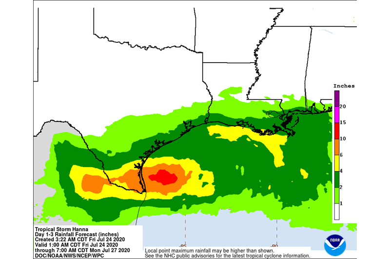
RAINFALL: Hanna is expected to produce 4 to 8 inches of rain with isolated maximum totals of 12 inches through Sunday night in south Texas. This rain may result in life-threatening flash flooding, rapid rises on small streams, and isolated minor to moderate river flooding in south Texas. 3 to 5 inches of rain is expected along the upper Texas and Louisiana coasts, and inland to the Mexican states of Coahuila, Nuevo Leon, and northern Tamaulipas.
SURF: Swells generated by Hanna are expected to increase and affect much of the Texas and Louisiana coasts during the next few days. These swells are likely to cause life-threatening surf and rip current conditions. Please consult products from your local weather office.