
NWS National Hurricane Center Miami FL AL092023
...DISTURBANCE EXPECTED TO BECOME A TROPICAL STORM BEFORE REACHING TEXAS...
...FLOODING RAINS AND COASTAL FLOODING ARE POSSIBLE...
SUMMARY OF 100 PM CDT...1800 UTC...INFORMATION
----------------------------------------------
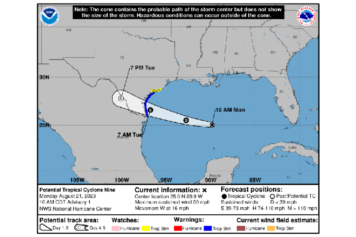
LOCATION...25.0N 91.0W
ABOUT 480 MI...770 KM ESE OF PORT MANSFIELD TEXAS
MAXIMUM SUSTAINED WINDS...35 MPH...55 KM/H
PRESENT MOVEMENT...W OR 275 DEGREES AT 16 MPH...26 KM/H
MINIMUM CENTRAL PRESSURE...1008 MB...29.77 INCHES
WATCHES AND WARNINGS
--------------------
CHANGES WITH THIS ADVISORY:
None.
SUMMARY OF WATCHES AND WARNINGS IN EFFECT:
A Tropical Storm Warning is in effect for...
* Mouth of Rio Grande to Port O'Connor, Texas
A Tropical Storm Watch is in effect for...
* Port O'Connor to Sargent, Texas
A Tropical Storm Warning means that tropical storm conditions are expected somewhere within the warning area, in this case within 24 hours.
A Tropical Storm Watch means that tropical storm conditions are possible within the watch area, in this case within 24 hours.
Interests elsewhere in eastern Texas and northern Mexico should monitor the progress of this system.
For storm information specific to your area, including possible inland watches and warnings, please monitor products issued by your local National Weather Service forecast office.
DISCUSSION AND OUTLOOK
----------------------
At 100 PM CDT (1800 UTC), the disturbance was centered near latitude 25.0 North, longitude 91.0 West. The system is moving toward the west near 16 mph (26 km/h). A fast motion to the west is expected to continue, and the system is forecast to move inland over south Texas early Tuesday.
Maximum sustained winds are near 35 mph (55 km/h) with higher gusts. Strengthening is forecast, and the system is expected to become a tropical storm before it reaches the Texas coast.
Satellite images indicate that the system continues to become better organized and it is expected to become a tropical depression later today.
* Formation chance through 48 hours...high...90 percent.
* Formation chance through 7 days...high...90 percent.
The estimated minimum central pressure is 1008 mb (29.77 inches).
HAZARDS AFFECTING LAND
----------------------
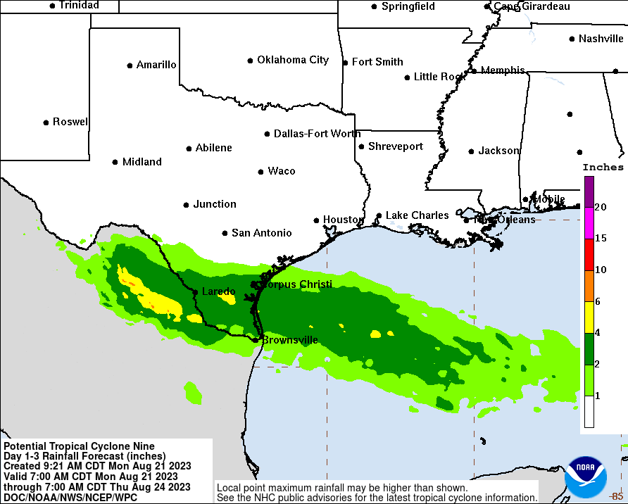
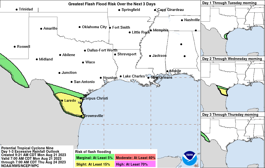
RAINFALL: Potential Tropical Cyclone Nine is expected to produce storm total rainfall amounts of 3 to 5 inches, with isolated higher amounts of 7 inches, across Southern Texas on Tuesday and Wednesday. This rainfall could lead to areas of flash and urban flooding.
Across Mexico, storm total rainfall of 4 to 6 inches, with local amounts of 10 inches, are expected across portions of Coahilla and Nuevo Leon on Tuesday and Wednesday. Areas of flash and urban flooding are expected.
WIND: Tropical storm conditions are expected in the warning area and are possible in the watch area by Tuesday morning.
STORM SURGE: The combination of a storm surge and the tide will cause normally dry areas near the coast to be flooded by rising waters moving inland from the shoreline. The water could reach the following heights above ground somewhere in the indicated areas if the peak surge occurs at the time of high tide...
Mouth of Rio Grande to Sargent, including Baffin Bay, Corpus Christi Bay and Matagorda Bay...1 to 3 ft
The deepest water will occur along the immediate coast near and to the north of the landfall location, where the surge will be accompanied by large waves. Surge-related flooding depends on the relative timing of the surge and the tidal cycle, and can vary greatly over short distances. For information specific to your area, please see products issued by your local National Weather Service forecast office.
SURF: Large swells generated by the disturbance will affect portions of southern Texas tonight through Tuesday. These swells are likely to cause life-threatening surf and rip current conditions. Please consult products from your local weather office.
Forecaster Cangialosi


