
Tropical Storm Arthur Intermediate Advisory Number 7A
NWS National Hurricane Center Miami FL AL012020
800 AM EDT Mon May 18 2020
SUMMARY OF 800 AM EDT...1200 UTC...INFORMATION
----------------------------------------------
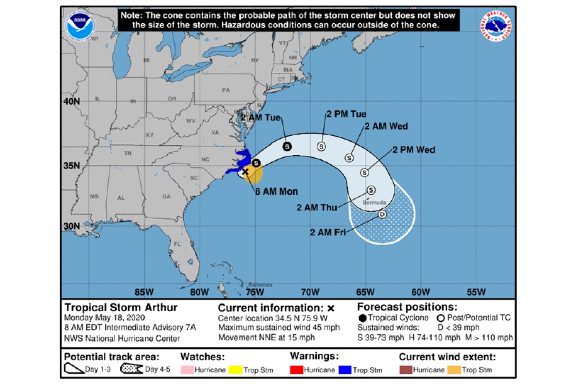
LOCATION...34.5N 75.9W
ABOUT 50 MI...85 KM ESE OF MOREHEAD CITY NORTH CAROLINA
ABOUT 50 MI...85 KM SSW OF CAPE HATTERAS NORTH CAROLINA
MAXIMUM SUSTAINED WINDS...45 MPH...75 KM/H
PRESENT MOVEMENT...NNE OR 25 DEGREES AT 15 MPH...24 KM/H
MINIMUM CENTRAL PRESSURE...1001 MB...29.56 INCHES
WATCHES AND WARNINGS
--------------------
CHANGES WITH THIS ADVISORY:
None.
SUMMARY OF WATCHES AND WARNINGS IN EFFECT:
A Tropical Storm Warning is in effect for...
* Surf City to Duck NC
* Pamlico and Albemarle Sounds
A Tropical Storm Warning means that tropical storm conditions are expected somewhere within the warning area.
For storm information specific to your area, including possible inland watches and warnings, please monitor products issued by your local National Weather Service forecast office.
DISCUSSION AND OUTLOOK
---------
At 800 AM EDT (1200 UTC), the center of Tropical Storm Arthur was located near latitude 34.5 North, longitude 75.9 West. Arthur is moving toward the north-northeast near 15 mph (24 km/h). A turn toward the northeast with an increase in forward speed is expected later today, followed by a turn toward the east on Tuesday. On the forecast track, the center of Arthur will approach the coast of North Carolina during the next few hours, and then move near or just east of the coast of North Carolina later today. Arthur is then forecast to turn away from the east coast of the United States tonight and Tuesday.
Maximum sustained winds are near 45 mph (75 km/h) with higher gusts. While some strengthening is forecast during the next 48 hours, Arthur is likely to lose its tropical characteristics on Tuesday.
Tropical-storm-force winds extend outward up to 90 miles (150 km) mainly to the east of the center. NOAA buoy 41025 located about 20 miles (30 km) south-southeast of Cape Hatteras, North Carolina, has recently reported a wind gust to 43 mph (69 km/h).
The estimated minimum central pressure reported from an Air Force Reserve Hurricane Hunter aircraft is 1001 mb (29.56 inches).
HAZARDS AFFECTING LAND
----------------------
WIND: Tropical storm conditions are expected within the Tropical Storm Warning area today.
RAINFALL: Arthur is expected to produce total rain accumulations of 1 to 3 inches over coastal North Carolina through this afternoon, with isolated maximum amounts of 5 inches.
SURF: Swells generated by Arthur are affecting portions of the southeast U.S. coast and are expected to spread northward along the U.S. mid-Atlantic coast during the next day or so. These swells could cause life-threatening surf and rip current conditions. Please consult products from your local weather office.


