
...HURRICANE WATCH ISSUED FOR PORTIONS OF HAITI...
Tropical Storm Melissa Advisory Number 1
NWS National Hurricane Center Miami FL AL132025
1100 AM EDT Tue Oct 21 2025
SUMMARY OF 1100 AM EDT...1500 UTC...INFORMATION
-----------------------------------------------
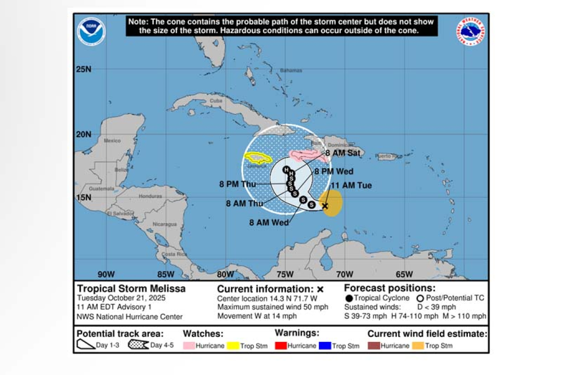
LOCATION...14.3N 71.7W
ABOUT 300 MI...480 KM S OF PORT AU PRINCE HAITI
MAXIMUM SUSTAINED WINDS...50 MPH...85 KM/H
PRESENT MOVEMENT...W OR 280 DEGREES AT 14 MPH...22 KM/H
MINIMUM CENTRAL PRESSURE...1003 MB...29.62 INCHES
WATCHES AND WARNINGS
--------------------
 CHANGES WITH THIS ADVISORY:
A Hurricane Watch has been issued for the southern peninsula of Haiti from the border with the Do-minican Republic to Port-Au-Prince. The government of Jamaica has issued a Tropical Storm Watch for the island.
SUMMARY OF WATCHES AND WARNINGS IN EFFECT:
A Hurricane Watch is in effect for...
* Border with Dominican Republic to Port-Au-Prince
A Tropical Storm Watch is in effect for...
* Jamaica
A Hurricane Watch means that hurricane conditions are possible within the watch area. A watch is typically issued 48 hours before the anticipated first occurrence of tropical-storm-force winds, condi-tions that make outside preparations difficult or dangerous.
A Tropical Storm Watch means that tropical storm conditions are possible within the watch area, generally within 48 hours.
Interests elsewhere in Haiti, the Dominican Republic, and Cuba should monitor the progress of Melis-sa.
For storm information specific to your area, please monitor products issued by your national meteor-ological service.
DISCUSSION AND OUTLOOK
----------------------
At 1100 AM EDT (1500 UTC), the center of the newly formed Tropical Storm Melissa was located near latitude 14.3 North, longitude 71.7 West. Melissa is moving toward the west near 14 mph (22 km/h). A decrease in forward speed and a gradual turn to the northwest and north is expected during the next few days. On the forecast track, Melissa is expected to approach the southwestern portion of Haiti and Jamaica later this week.
Surface observations and satellite data indicate that the maximum sustained winds are near 50 mph (85 km/h) with higher gusts. Gradual strengthening is expected during the next few days.
Tropical-storm-force winds extend outward up to 115 miles (185 km) from the center.
The estimated minimum central pressure is 1003 mb (29.62 inches).
HAZARDS AFFECTING LAND
----------------------
WIND: Hurricane conditions are possible within the watch area in Haiti beginning on Thursday. Tropi-cal storm conditions could begin in Jamaica on Thursday or Friday.
RAINFALL: Melissa will bring heavy rainfall to Haiti and the Dominican Republic, with totals of 5 to 10 inches expected through Friday. Additional heavy rainfall is possible beyond Friday, but uncertainty regarding the track and forward speed of Melissa reduces confidence in exact amounts. Areas of sig-nificant flash flooding and mudslides are possible.
Over Aruba, Puerto Rico and Jamaica rainfall of 1 to 3 inches is expected through Friday. Flash and urban flooding will be possible across Puerto Rico through at least Friday.
SURF: Swells generated by Melissa are expected to spread to Hispaniola, Jamaica, and eastern Cuba during the next couple of days. Please consult products from your local weather office.
Forecaster Cangialosi/Bucci


