
...STRONG WINDS...STORM SURGE...AND HEAVY RAIN EXPECTED TO BEGIN THERE BY THIS EVENING...
Hurricane Paulette Advisory Number 27
NWS National Hurricane Center Miami FL AL172020
1100 AM AST Sun Sep 13 2020
SUMMARY OF 1100 AM AST...1500 UTC...INFORMATION
-----------------------------------------------
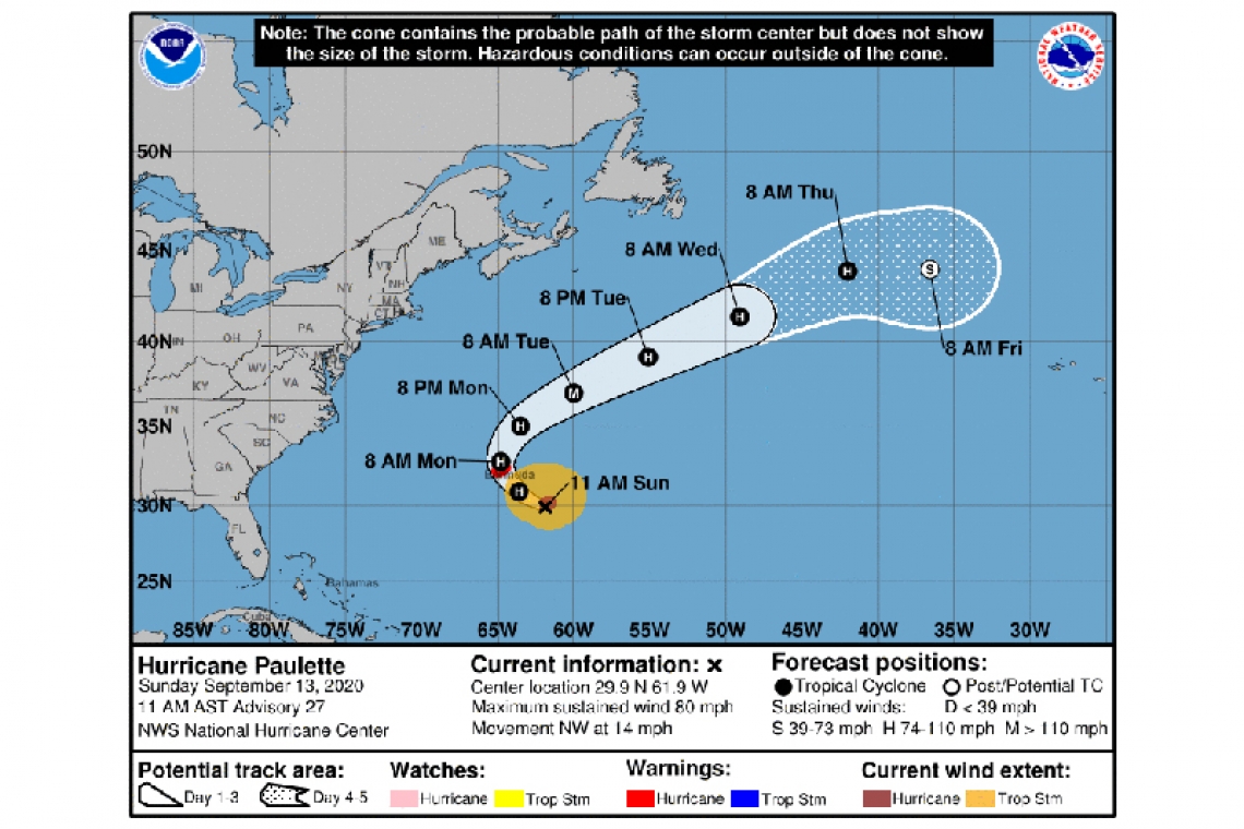
LOCATION...29.9N 61.9W
ABOUT 240 MI...385 KM SE OF BERMUDA
MAXIMUM SUSTAINED WINDS...80 MPH...130 KM/H
PRESENT MOVEMENT...NW OR 305 DEGREES AT 14 MPH...22 KM/H
MINIMUM CENTRAL PRESSURE...976 MB...28.82 INCHES
WATCHES AND WARNINGS
--------------------
CHANGES WITH THIS ADVISORY:
None.
SUMMARY OF WATCHES AND WARNINGS IN EFFECT:
A Hurricane Warning is in effect for...
* Bermuda
A Hurricane Warning means that hurricane conditions are expected somewhere within the warning area. Tropical-storm-force winds that make outside preparations difficult or dangerous are expected to reach Bermuda this afternoon or evening. Preparations to protect life and property should be rushed to completion.
For storm information specific to your area, please monitor products issued by your national meteorological service.
DISCUSSION AND OUTLOOK
----------------------
At 1100 AM AST (1500 UTC), the center of Hurricane Paulette was located near latitude 29.9 North, longitude 61.9 West. Paulette is moving toward the northwest near 13 mph (20 km/h), and this general motion is expected through tonight. A turn toward the north with a decrease in forward speed is forecast on Monday, followed by a faster northeastward motion Monday night and Tuesday. On the forecast track, the center of Paulette will move near or over Bermuda Monday morning.
Maximum sustained winds are near 80 mph (130 km/h) with higher gusts. Strengthening is forecast, and Paulette is expected to be a dangerous hurricane when it approaches Bermuda late tonight and early Monday. Some further strengthening is possible when Paulette turns northeastward and moves away from Bermuda late Monday through Tuesday.
Hurricane-force winds extend outward up to 60 miles (95 km) from the center and tropical-storm-force winds extend outward up to 195 miles (315 km).
The estimated minimum central pressure is 976 mb (28.82 inches).
HAZARDS AFFECTING LAND
----------------------
WIND: Hurricane conditions are expected to reach Bermuda by tonight or early Monday. Winds are expected to first reach tropical storm strength this afternoon or evening, making outside preparations difficult or dangerous. Preparations to protect life and property should be rushed to completion.
STORM SURGE: A dangerous storm surge is expected to produce significant coastal flooding on Bermuda in areas of onshore winds. Near the coast, the surge will be accompanied by large and destructive waves.
RAIN: Paulette will bring periods of heavy rain to Bermuda through Monday, with rainfall of 3 to 6 inches expected.
SURF: Swells generated by Paulette are affecting portions of the Leeward Islands, the Greater Antilles, the Bahamas, Bermuda, and the east coast of the United States. These swells are likely to cause life-threatening surf and rip current conditions. Please consult products from your local weather office.


