
...TROPICAL STORM WARNINGS ISSUED FOR PORTIONS OF NICARAGUA AND COSTA RICA...
Potential Tropical Cyclone Two Advisory Number 12
NWS National Hurricane Center Miami FL AL022022
1100 AM EDT Thu Jun 30 2022
SUMMARY OF 1100 AM EDT...1500 UTC...INFORMATION
-----------------------------------------------
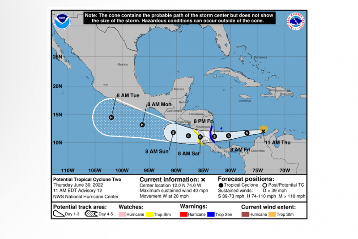
LOCATION...12.0N 74.0W
ABOUT 660 MI...1065 KM E OF BLUEFIELDS NICARAGUA
MAXIMUM SUSTAINED WINDS...40 MPH...65 KM/H
PRESENT MOVEMENT...W OR 270 DEGREES AT 20 MPH...31 KM/H
MINIMUM CENTRAL PRESSURE...1008 MB...29.77 INCHES
WATCHES AND WARNINGS
--------------------
CHANGES WITH THIS ADVISORY:
The government of Nicaragua has issued a Tropical Storm Warning for the Caribbean coast of Nicaragua from the Nicaragua/Costa Rica border northward to Sandy Bay Sirpi, and a Tropical Storm Watch for the Pacific coast of Nicaragua from the Nicaragua/Costa Rica border northward to Puerto Sandino.
The government of Costa Rica has issued a Tropical Storm Warning for the Caribbean coast of Costa Rica from Limon northward to the Nicaragua/Costa Rica border, and a Tropical Storm Watch for the Pacific coast of Costa Rica from Cabo Blanco northward to the Nicaragua/Costa Rica border.
SUMMARY OF WATCHES AND WARNINGS IN EFFECT:
A Hurricane Watch is in effect for...
* Nicaragua/Costa Rica border to Laguna de Perlas Nicaragua
A Tropical Storm Warning is in effect for...
* San Andres Colombia
* Limon Costa Rica northward to Sandy Bay Sirpi Nicaragua
A Tropical Storm Watch is in effect for...
* Cabo Blanco Costa Rica northward to Puerto Sandino Nicaragua
A Hurricane Watch means that hurricane conditions are possible within the watch area, in this case within 36 hours.
A Tropical Storm Warning means that tropical storm conditions are expected somewhere within the warning area within 36 hours.
A Tropical Storm Watch means that tropical storm conditions are possible within the watch area, generally within 48 hours.
Interests elsewhere along both the Caribbean and Pacific coasts of Nicaragua and Costa Rica should monitor the progress of this
system.
For storm information specific to your area, please monitor products issued by your national meteorological service.
DISCUSSION AND OUTLOOK
----------------------
 At 1100 AM EDT (1500 UTC), the disturbance was centered near latitude 12.0 North, longitude 74.0 West. The system is moving
toward the west near 20 mph (31 km/h), and a continued mostly westward motion with a decrease in forward speed is expected
through Saturday. On the forecast track, the system will move across the southwestern Caribbean Sea today through Friday, cross southern Nicaragua or northern Costa Rica Friday night, and emerge over the eastern Pacific Ocean on Saturday.
Maximum sustained winds are near 40 mph (65 km/h) with higher gusts. Some strengthening is forecast through Friday while the system approaches Central America. Weakening is expected while the system crosses Central America, but restrengthening is forecast on Saturday once it moves over the Pacific Ocean.
Conditions appear conducive for development, and the disturbance is expected become a tropical storm while slowing down over the southwestern Caribbean Sea.
* Formation chance through 48 hours... high...90 percent.
* Formation chance through 5 days...high...90 percent.
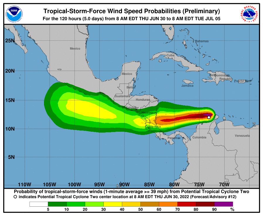
Tropical-storm-force winds extend outward up to 80 miles (130 km) from the center.
The estimated minimum central pressure is 1008 mb (29.77 inches).
HAZARDS AFFECTING LAND
----------------------
RAINFALL: The Potential Tropical Cyclone is expected to produce heavy rain across portions of northern Colombia through this
morning, then across Nicaragua and Costa Rica by Friday. The following storm total rainfall amounts are expected:
Northern Colombia: 3 to 5 inches.
Nicaragua and Costa Rica: 4 to 8 inches, with isolated higher totals around 12 inches.
This rainfall is expected to result in areas of life-threatening flash flooding and mudslides.
WIND: Hurricane conditions are possible within the Hurricane Watch area in Nicaragua late Friday. Tropical storm conditions are
expected over San Andres Island on Friday. Tropical storm conditions are expected within the Tropical Storm Warning areas
in Nicaragua and Costa Rica by late Friday. Tropical storm conditions are possible within the Tropical Storm Watch areas along
the Pacific coasts of Costa Rica and Nicaragua on Saturday.
STORM SURGE: Storm surge could raise water levels by as much as 1 to 3 feet above normal tide levels along the immediate coast of Nicaragua near and to the north of where the center makes landfall.
Forecaster Pasch


