
DATE ISSUED: Saturday, 16 August 2025 @ 06:00 LST (10:00 UTC)
VALID UNTIL: Sunday morning (06:00 LST) 17 August 2025
…A TROPICAL STORM WATCH IS IN EFFECT FOR ST. MAARTEN…
…A FLOOD ADVISORY IS IN EFFECT…
…A SMALL CRAFT ADVISORY IS IN EFFECT…
WEATHER:
Today through Sunday morning: Cloudy to overcast and breezy with intermittent showers and thunderstorms.
Forecast High: 30°C / 86°F
Forecast Low: 24°C / 75°F
Sunset Today: 6:38 P.M.
Sunrise Tomorrow: 5:55 A.M.
SURFACE WINDS:
This morning: Westerly to southwesterly with a moderate to fresh breeze at 13 to 24 mph and higher gusts, mainly in or near showers.
This afternoon through Sunday morning: Southerly to southeasterly with a moderate to fresh breeze at 16 to 26 mph and occasional higher gusts.
SYNOPSIS:
Abundant moisture and instability associated with the passage of Hurricane Erin will cause cloudy skies, intermittent showers and thunderstorms across the local region. Some of these showers may be heavy at times, and could lead to street-flooding and/or rock-slides. Road-users are advised to be vigilant and exercise caution.
Moderate to rough seas, with ground swells are expected throughout the weekend, particularly along the northern and eastern shores. Interests along the coast should take the necessary actions to preserve life and property. A Small Craft Advisory is in effect until further notice, which may be upgraded to a Small Craft Warning later today.
STATE OF THE SEA: Moderate to rough
WAVES/SWELLS: 5 to 9 feet
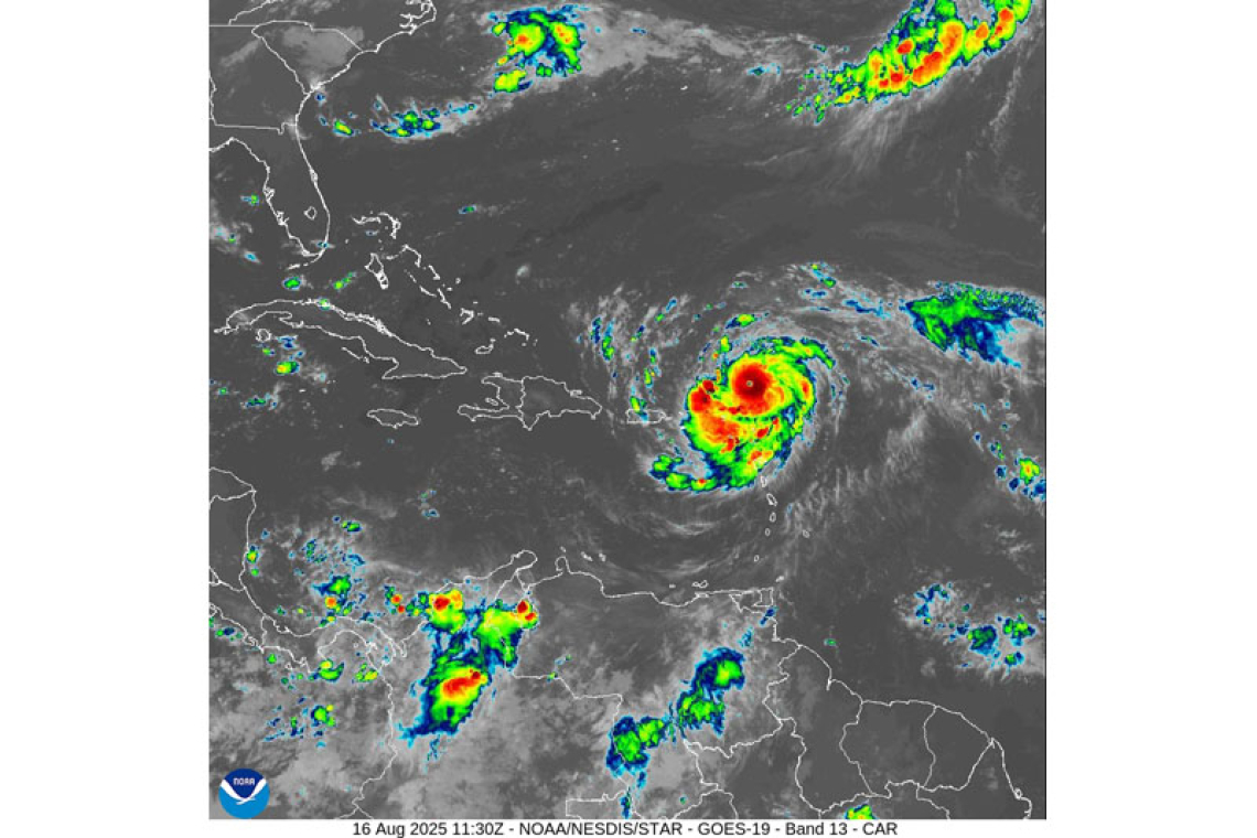
SPECIAL FEATURE:
At 5:00am, the center of now Category-3-Hurricane Erin was located near 19.8°N 61.1°W, or about 180 miles northeast of St. Maarten. Erin has maximum sustained winds up to 120 mph and is moving towards the west-northwest at 20 mph. Further strengthening is forecast, and Erin could become a Cat-4 later today. At its closest point, Hurricane Erin will be approximately 145 miles north-northeast of St. Maarten later this morning.
All are advised to remain updated on the progress of Erin.
The Meteorological Department of St. Maarten will continue to monitor Erin & any other systems, and inform the public accordingly.
FORECASTER: Connor
3-DAY FORECAST
|
DAY
|
Saturday
|
Sunday
|
Monday
|
|
WEATHER
|
Cloudy/Overcast, Breezy,
Intermittent Showers & Thunderstorms
|
Cloudy, Breezy,
Scattered Showers, poss. Thunderstorms |
Cloudy/Partly Cloudy,
Isolated Showers, possible Thunder |
|
HIGH TEMP
|
30°C / 86°F
|
30°C / 86°F
|
31°C / 88°F
|
|
LOW TEMP
|
24°C / 75°F
|
25°C / 77°F
|
26°C / 79°F
|
|
SUNRISE
|
05:55 AM
|
05:55 AM
|
05:56 AM
|
|
SUNSET
|
06:38 PM
|
06:37 PM
|
06:37 PM
|


