
Hurricane Erin Intermediate Advisory Number 18A
NWS National Hurricane Center Miami FL AL052025
800 PM AST Fri Aug 15 2025
SUMMARY OF 800 PM AST...0000 UTC...INFORMATION
----------------------------------------------
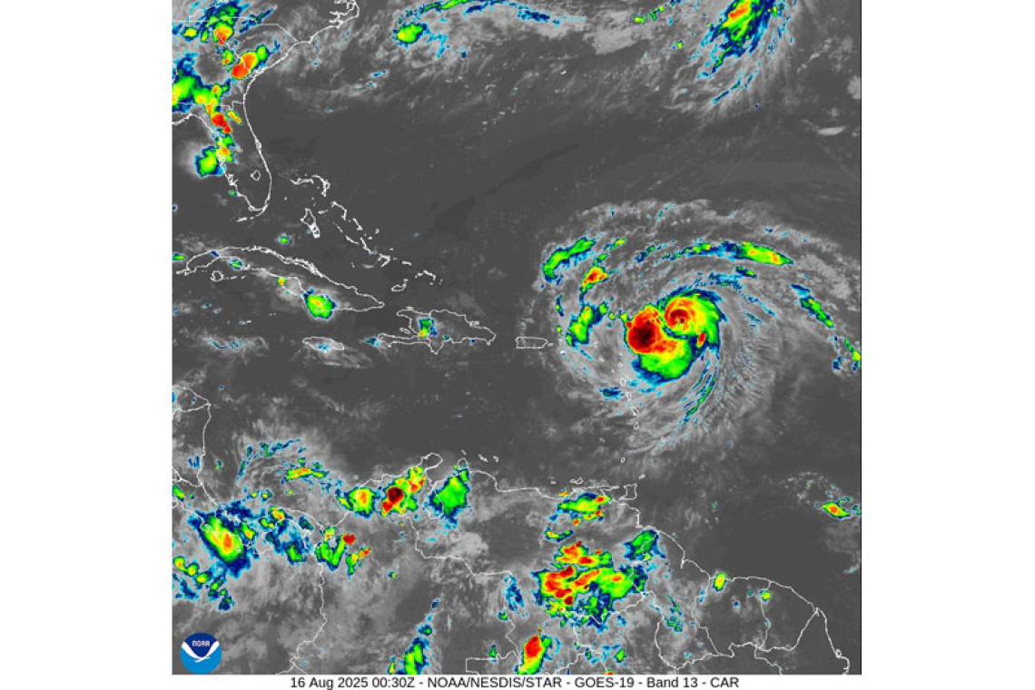
LOCATION...19.4N 58.5W
ABOUT 310 MI...500 KM ENE OF THE NORTHERN LEEWARD ISLANDS
MAXIMUM SUSTAINED WINDS...85 MPH...140 KM/H
PRESENT MOVEMENT...WNW OR 290 DEGREES AT 17 MPH...28 KM/H
MINIMUM CENTRAL PRESSURE...982 MB...29.00 INCHES
WATCHES AND WARNINGS
--------------------
CHANGES WITH THIS ADVISORY:
The Meteorological Service of Antigua/Barbuda has discontinued the Tropical Storm Watch for the island of Barbuda.
SUMMARY OF WATCHES AND WARNINGS IN EFFECT:
A Tropical Storm Watch is in effect for...
* Anguilla
* St. Martin and St. Barthelemy
* Saba and St. Eustatius
* Sint Maarten
A Tropical Storm Watch means that tropical storm conditions are possible within the watch area, in this case over the next 24 hours.
Interests elsewhere in the northern Leeward Islands, Virgin Islands, and Puerto Rico, as well as in the Turks and Caicos and the southeastern Bahamas should monitor the progress of Erin.
For storm information specific to your area, please monitor products issued by your national meteorological service.
DISCUSSION AND OUTLOOK
----------------------
At 800 PM AST (0000 UTC), the center of Hurricane Erin was located near latitude 19.4 North, longitude 58.5 West. Erin is moving toward the west-northwest near 17 mph (28 km/h). This motion is expected to continue through the weekend with a gradual decrease in forward speed. On the forecast track, the center of Erin is likely to move just north of the northern Leeward Islands, the Virgin Islands, and
Puerto Rico over the weekend.
NOAA Hurricane Hunter aircraft data indicates that maximum sustained winds have increased to near 85 mph (140 km/h) with higher gusts. Steady to rapid strengthening is expected over the next few days, and Erin is forecast to become a major hurricane during the weekend. Both NOAA and Air Force Reserve Hurricane Hunter aircraft are investigating Erin this evening.
Hurricane-force winds extend outward up to 25 miles (35 km) from the center and tropical-storm-force winds extend outward up to 115 miles (185 km).
The minimum central pressure estimated from NOAA Hurricane Hunter dropsonde data is 982 mb (29.00 inches).
HAZARDS AFFECTING LAND
----------------------
RAINFALL: The outer bands of Erin are expected to produce areas of heavy rainfall tonight into Sunday across the northern Leeward Islands, the Virgin Islands, and Puerto Rico. Rainfall totals of 2 to 4 inches, with isolated totals of 6 inches, are expected. This rainfall may lead to isolated and locally considerable flash and urban flooding, along with landslides or mudslides.
WIND: Tropical storm conditions are possible within the watch area by early Saturday.
SURF: Swells generated by Erin will begin affecting portions of the northern Leeward Islands, the Virgin Islands and Puerto Rico by this weekend, and will likely spread to the western Atlantic early next week. These swells are likely to cause life-threatening surf and rip current conditions. Please consult products from your local weather forecast office.
Forecaster Papin


