
Tropical Depression Thirteen Intermediate Advisory Number 6A
NWS National Hurricane Center Miami FL AL132020
800 AM AST Fri Aug 21 2020
SUMMARY OF 800 AM AST...1200 UTC...INFORMATION
----------------------------------------------
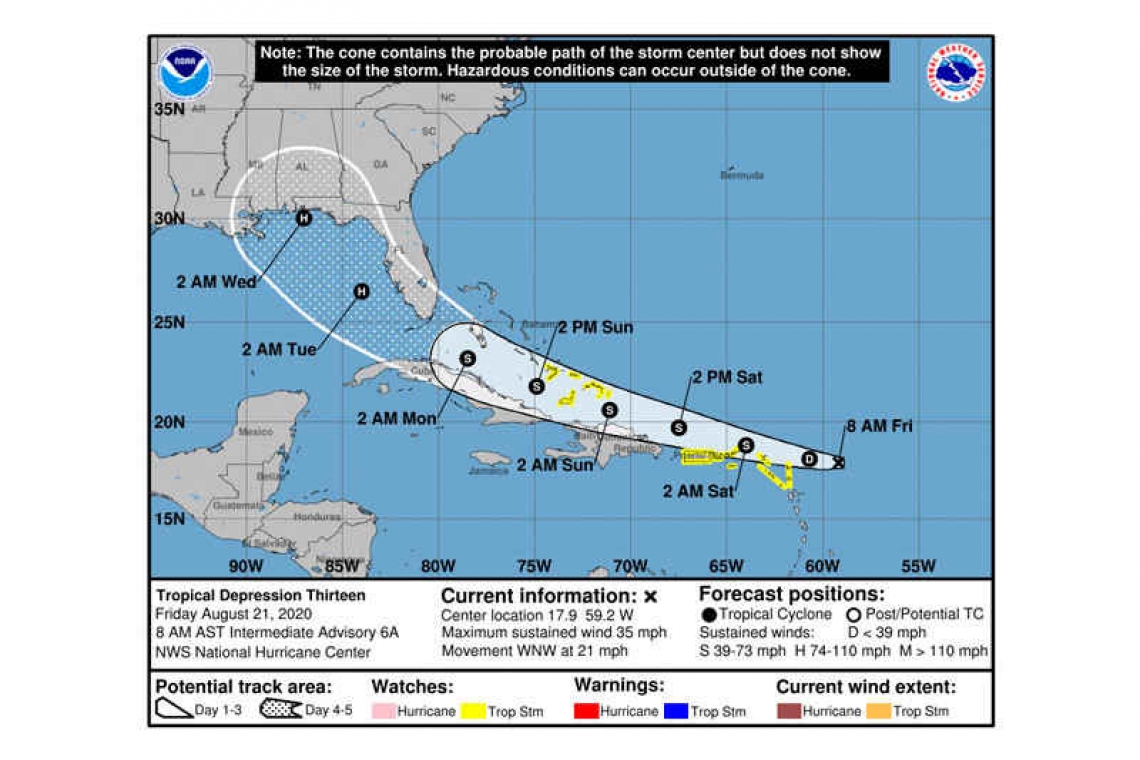
LOCATION...17.9 59.2W
ABOUT 255 MI...415 KM E OF THE NORTHERN LEEWARD ISLANDS
MAXIMUM SUSTAINED WINDS...35 MPH...55 KM/H
PRESENT MOVEMENT...WNW OR 285 DEGREES AT 21 MPH...33 KM/H
MINIMUM CENTRAL PRESSURE...1008 MB...29.77 INCHES
WATCHES AND WARNINGS
--------------------
CHANGES WITH THIS ADVISORY:
None.
SUMMARY OF WATCHES AND WARNINGS IN EFFECT:
A Tropical Storm Watch is in effect for...
* The southeastern Bahamas and the Turks and Caicos Islands
* Puerto Rico, Vieques and Culebra
* U.S. Virgin Islands
* British Virgin Islands
* Saba and St. Eustatius
* St. Maarten
* St. Martin and St. Barthelemy
* Antigua, Barbuda, St. Kitts, Nevis, and Anguilla
A Tropical Storm Watch means that tropical storm conditions are possible within the watch area, generally within 48 hours.
Interests elsewhere in the northern Leeward Islands, the Virgin Islands, Puerto Rico, and the Dominican Republic should monitor the progress of this system, as additional tropical storm watches or warnings will likely be required for portions of those areas later today. Interests in Cuba and the remainder of the Bahamas should also monitor the progress of this system.
DISCUSSION AND OUTLOOK
----------------------
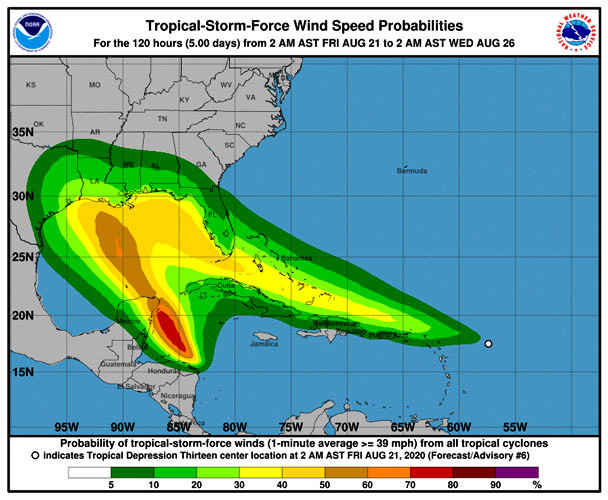
At 800 AM AST (1200 UTC), the center of Tropical Depression Thirteen was located near latitude 17.9 North, longitude 59.2 West. The depression is moving toward the west-northwest near 21 mph (33 km/h), and this motion is expected to continue for the next few days. On the forecast track, the depression is expected to move near or north of the northern Leeward Islands later today, near or north of the Virgin Islands and Puerto Rico on Saturday, and near or north of Hispaniola Saturday night.
Maximum sustained winds remain near 35 mph (55 km/h) with higher gusts. Gradual strengthening is forecast, and the depression is likely to become a tropical storm by the weekend.
The estimated minimum central pressure is 1008 mb (29.77 inches).
HAZARDS AFFECTING LAND
----------------------
RAINFALL: The depression is expected to produce 3 to 6 inches of rain over Puerto Rico and the Virgin Islands through Sunday. Locally heavy rainfall could lead to flash and urban flooding, as well as an increased potential for mudslides. Some rivers may overflow their banks.
1 to 3 inches of rain with isolated maximum totals of 5 inches is expected over the northern Leeward Islands, the Dominican Republic, Haiti, the Turks and Caicos and southeast Bahamas.
WIND: Tropical storm conditions are possible within the watch area later today through Saturday night.
Forecaster Pasch


