
...EXPECTED TO BRING STRONG WINDS AND HEAVY RAIN TO PORTIONS OF THE LEEWARD ISLANDS LATER TODAY AND TONIGHT...
Tropical Storm Bret Intermediate Advisory Number 12A
NWS National Hurricane Center Miami FL AL032023
800 AM AST Thu Jun 22 2023
SUMMARY OF 800 AM AST...1200 UTC...INFORMATION
----------------------------------------------
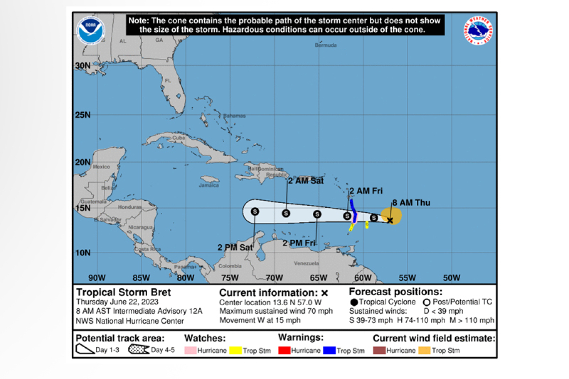
LOCATION...13.6N 57.0W
ABOUT 170 MI...265 KM E OF BARBADOS
MAXIMUM SUSTAINED WINDS...70 MPH...110 KM/H
PRESENT MOVEMENT...W OR 280 DEGREES AT 15 MPH...24 KM/H
MINIMUM CENTRAL PRESSURE...996 MB...29.42 INCHES
WATCHES AND WARNINGS
--------------------
CHANGES WITH THIS ADVISORY:
None.
SUMMARY OF WATCHES AND WARNINGS IN EFFECT:
A Hurricane Watch is in effect for...
* St. Lucia
A Tropical Storm Warning in in effect for...
* Dominica
* St. Lucia
* Martinique
A Tropical Storm Watch is in effect for...
* Barbados
* St. Vincent and the Grenadines
A Hurricane Watch means that hurricane conditions are possible within the watch area, in this case within the next 24 hours.
A Tropical Storm Warning means that tropical storm conditions are expected somewhere within the warning area, in this case within 24 hours.
A Tropical Storm Watch means that tropical storm conditions are possible within the watch area, in this case within the next 24 hours.
Interests elsewhere in the Lesser Antilles should monitor the progress of Bret. Additional watches or warnings may be required later today.
DISCUSSION AND OUTLOOK
----------------------
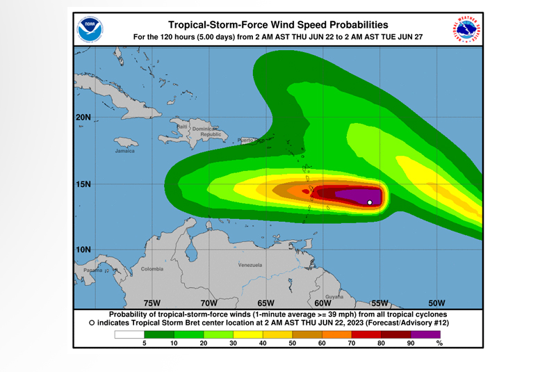
At 800 AM AST (1200 UTC), the center of Tropical Storm Bret was located near latitude 13.6 North, longitude 57.0 West. Bret is moving toward the west near 15 mph (24 km/h), and this general motion with an increase in forward speed is expected during the next few days. On the forecast track, the center of Bret is expected to approach the Lesser Antilles today, move across the Lesser Antilles this evening and tonight, and then move westward across the eastern and central Caribbean Sea Friday and Saturday.
Maximum sustained winds are near 70 mph (110 km/h) with higher gusts. Little change in strength is forecast today while Bret approaches the Lesser Antilles. Weakening is anticipated to begin tonight or Friday after Bret passes the Lesser Antilles, and the system is likely to dissipate over the central Car-ibbean Sea by
Saturday night.
Tropical-storm-force winds extended outward up to 115 miles (185 km) from the center, especially to the north.
The minimum central pressure partially based on data from the Air Force Hurricane Hunters is 996 mb (29.42 inches).
The St. Maarten Meteorological Department (SMD) in its 6:00am forcast said moisture and instability moving into the local area due to the proximity of Tropical Storm Bret will cause an increasing chance of cloudy periods and isolated showers. Some of these showers may be heavy and can be accompa-nied by thunder, as well as gusty winds.
Above-normal seas, peaking up to 9 feet are expected through the next couple of days. As a result, a Small Craft Advisory is now in effect for St. Maarten. Small-craft operators and swimmers should con-tinue exercising caution.
STATE OF THE SEA: Moderate to rough
WAVES/SWELLS: 5 to 9 feet
The center of Tropical Storm Bret was located about 530 miles southeast of St. Maarten at 5:00am
(09:00 UTC) and its closest point to St. Maarten is predicted to be about 265 miles south-southwest on Friday morning.
WIND: Hurricane conditions are possible in the hurricane watch area this evening or tonight. Tropical storm conditions are expected within the tropical storm warning areas and possible within the watch areas later today and tonight.
RAINFALL: Storm total rainfall amounts of 3 to 6 inches with maximum amounts of 10 inches are pos-sible across portions of the Lesser Antilles from Guadeloupe south to St. Vincent and the Grenadines, including Barbados. The heavy rainfall could lead to flash flooding, especially across areas of higher terrain. Urban flooding is also possible.
SURF: Swells generated by Bret are beginning to affect portions of the Lesser Antilles. These swells are likely to cause life-threatening surf and rip current conditions.


