
...LIFE-THREATENING FLASH FLOODS AND MUDSLIDES POSSIBLE FROM HEAVY RAINS OVER CENTRAL AMERICA AND SOUTHERN MEXICO THROUGH TUESDAY...
Hurricane Julia Intermediate Advisory Number 12A
NWS National Hurricane Center Miami FL AL132022
800 AM EDT Sun Oct 09 2022
SUMMARY OF 800 AM EDT...1200 UTC...INFORMATION
----------------------------------------------
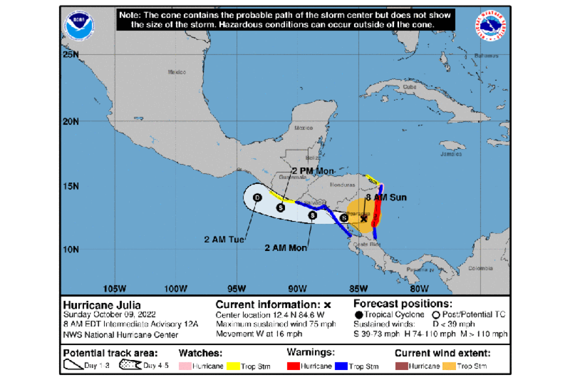
LOCATION...12.4N 84.6W
ABOUT 60 MI...100 KM WNW OF BLUEFIELDS NICARAGUA
ABOUT 115 MI...190 KM E OF MANAGUA NICARAGUA
MAXIMUM SUSTAINED WINDS...75 MPH...120 KM/H
PRESENT MOVEMENT...W OR 265 DEGREES AT 16 MPH...26 KM/H
MINIMUM CENTRAL PRESSURE...989 MB...29.20 INCHES
WATCHES AND WARNINGS
--------------------
CHANGES WITH THIS ADVISORY:
The government of Colombia has discontinued the Tropical Storm Warning for San Andres, Providencia, and Santa Catalina Islands.
SUMMARY OF WATCHES AND WARNINGS IN EFFECT:
A Hurricane Warning is in effect for...
* Nicaragua from Bluefields to Puerto Cabezas
A Hurricane Watch is in effect for...
* Nicaragua north of Puerto Cabezas to the Honduras/Nicaragua border
A Tropical Storm Warning is in effect for...
* Nicaragua south of Bluefields to the Nicaragua/Costa Rica border
* Nicaragua north of Puerto Cabezas to the Honduras/Nicaragua border
* Pacific coast of Nicaragua
* Pacific coast of Honduras
* Coast of El Salvador
A Tropical Storm Watch is in effect for...
* Honduras from the Nicaragua/Honduras border to Punta Patuca
* Pacific coast of Guatemala
A Hurricane Warning means that hurricane conditions are expected somewhere within the warning area.
A Hurricane Watch means that hurricane conditions are possible within the watch area.
A Tropical Storm Warning means that tropical storm conditions are expected somewhere within the warning area within 36 hours.
A Tropical Storm Watch means that tropical storm conditions are possible within the watch area.
For storm information specific to your area, please monitor products issued by your national meteorological service.
DISCUSSION AND OUTLOOK
----------------------
At 800 AM EDT (1200 UTC), the center of Hurricane Julia was located inland over Nicaragua near latitude 12.4 North, longitude 84.6 West. Julia is moving toward the west near 16 mph (26 km/h). This general motion is expected to continue through tonight, followed by a slight turn to the west-northwest on Monday. On the forecast track, the center of Julia is expected to continue moving across Nicaragua today and emerge over the eastern Pacific by tonight. Julia is then forecast to move near or along the Pacific coasts of Honduras, El Salvador, and Guatemala on Monday and Monday night.
Maximum sustained winds have decreased to near 75 mph (120 km/h) with higher gusts. Additional weakening is expected today as Julia moves over Nicaragua, but it is still forecast to be a tropical storm when it emerges off the Pacific coast of Nicaragua by tonight. Julia is forecast to weaken to a tropical depression on Monday night and dissipate by Tuesday.
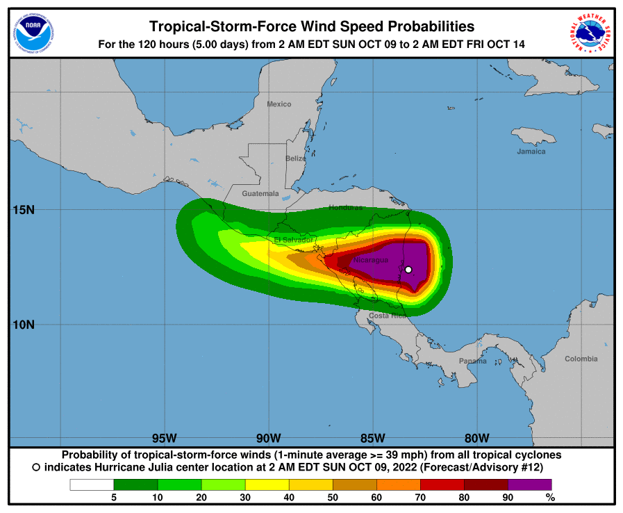
Hurricane-force winds extend outward up to 35 miles (55 km) from the center and tropical-storm-force winds extend outward up to 115 miles (185 km). The Bluefields International Airport in Nicaragua reported a sustained wind of 81 mph (130 km/h) a few hours ago a little after Julia had made landfall.
The estimated minimum central pressure is 989 mb (29.20 inches).
HAZARDS AFFECTING LAND
----------------------
WIND: Hurricane conditions will continue near Julia's center and along the coast of Nicaragua within the warning area this morning. Hurricane conditions are possible along the coast of Nicaragua within the hurricane watch area this morning.
Tropical storm conditions will continue along the Caribbean coast of Nicaragua within the tropical storm warning areas through this morning. Tropical storm conditions are possible along the coast of Honduras within the watch area through this morning.
Tropical storm conditions are expected along the Pacific coasts of Nicaragua, Honduras, and El Salvador within the warning area beginning this afternoon into tonight. Tropical storm conditions are possible along the Pacific coast of Guatemala within the watch area on Monday.
RAINFALL: Julia is expected to produce the following rainfall accumulations through early Tuesday:
Nicaragua and El Salvador...5 to 10 inches, isolated 15 inches.
Honduras, Belize, northern Guatemala, and the Isthmus of Tehuantepec in Mexico...3 to 6 inches, isolated 10 inches.
San Andres, Providencia, and Panama...an additional 2 to 4 inches,isolated 12 inch storm total amounts.
Southern Guatemala and Costa Rica...4 to 8 inches, isolated 12 inches.
This rainfall may cause life-threatening flash floods and mudslides across Central America today and Monday. Flash flooding is anticipated across the Isthmus of Tehuantepec in Mexico early this week.
STORM SURGE: A dangerous storm surge is likely still occurring along the coast of Nicaragua in areas of onshore winds, but water levels should subside today. Large and damaging waves will likely accompany the storm surge near the coast.
SURF: Swells generated by Julia are affecting Jamaica, Providencia, and San Andres, and the coast of Central America. These swells are likely to cause life-threatening surf and rip current conditions. Please consult products from your local weather office.
Forecaster Berg


