...TROPICAL-STORM-FORCE WINDS APPROACHING SOUTHWEST FLORIDA COAST...
Tropical Storm Eta Intermediate Advisory Number 44A
NWS National Hurricane Center Miami FL AL292020
700 AM EST Wed Nov 11 2020
SUMMARY OF 700 AM EST...1200 UTC...INFORMATION
----------------------------------------------
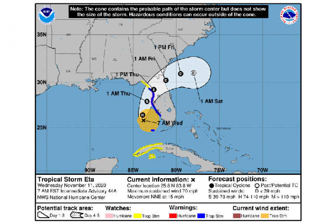
LOCATION...25.8N 83.8W
ABOUT 130 MI...210 KM WSW OF FT. MYERS FLORIDA
ABOUT 170 MI...270 KM SSW OF TAMPA FLORIDA
MAXIMUM SUSTAINED WINDS...70 MPH...110 KM/H
PRESENT MOVEMENT...NNE OR 15 DEGREES AT 15 MPH...24 KM/H
MINIMUM CENTRAL PRESSURE...984 MB...29.06 INCHES
WATCHES AND WARNINGS
--------------------
CHANGES WITH THIS ADVISORY:
None.
SUMMARY OF WATCHES AND WARNINGS IN EFFECT:
A Hurricane Watch is in effect for...
* Anna Maria Island to Yankeetown
A Tropical Storm Warning is in effect for...
* Dry Tortugas
* Bonita Beach to Suwannee River Florida
A Storm Surge Watch is in effect for...
* Bonita Beach to Steinhatchee River Florida, including Tampa Bay and Charlotte Harbor
A Tropical Storm Watch is in effect for...
* The Cuban provinces of La Habana, Artemisa, Mayabeque, Pinar del
Rio, and the Isle of Youth
* North of the Suwannee River to Aucilla River Florida
A Hurricane Watch means that hurricane conditions are possible within the watch area, in this case within 24 hours.
A Tropical Storm Warning means that tropical storm conditions are expected somewhere within the warning area, in this case within 24 hours.
A Storm Surge Watch means there is a possibility of life-threatening inundation, from rising water moving inland from the coastline, in the indicated locations during the next 48 hours.
A Tropical Storm Watch means that tropical storm conditions are possible within the watch area.
Interests elsewhere along the Gulf Coast of Florida should monitor the progress of Eta. Additional warnings may be required along portions of the Florida Peninsula today.
For storm information specific to your area in the United States, including possible inland watches and warnings, please monitor products issued by your local National Weather Service forecast office. For storm information specific to your area outside of the United States, please monitor products issued by your national meteorological service.
DISCUSSION AND OUTLOOK
----------------------
At 700 AM EST (1200 UTC), the center of Tropical Storm Eta was located by a NOAA reconnaissance aircraft and NOAA Doppler weather radars near latitude 25.8 North, longitude 83.8 West. Eta is moving toward the north-northeast near 15 mph (24 km/h), and this general motion is expected to continue through Thursday. On the forecast track, the center of Eta will move closer to but offshore of the southwest coast of Florida today, approach the west-central coast of Florida tonight, and move inland over the northern portion of the Florida peninsula on Thursday. Eta is expected to move northeastward into the western Atlantic late Thursday or early Friday.
Reports from the aircraft indicate that maximum sustained winds are near 70 mph (110 km/h) with higher gusts. Eta is expected to be near or at hurricane strength tonight as it approaches the west coast of Florida, with rapid weakening expected after landfall on Thursday.
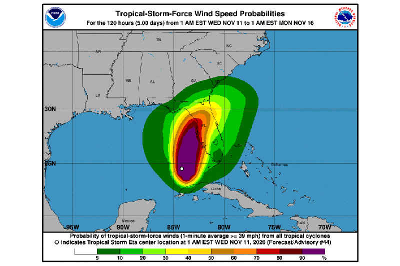
Tropical-storm-force winds extend outward up to 115 miles (185 km) from the center. A University of South Florida COMPS buoy just southeast of Eta's center recently measured a sustained wind of 49 mph (79 km/h) and a gust to 65 mph 104 (km/h). Doppler radars indicate that tropical-storm-force winds are located just offshore the southwestern coast of Florida. Across the lower Florida Keys, a sustained wind of 43 mph (69 km/h) and a gust to 56 mph (90 km/h) were recently reported at Sand Key.
The minimum central pressure recently measured by the NOAA Hurricane Hunter aircraft was 984 mb (29.06 inches).
HAZARDS AFFECTING LAND
----------------------
STORM SURGE: The combination of a dangerous storm surge and the tide will cause normally dry areas near the coast to be flooded by rising waters moving inland from the shoreline. The water could reach the following heights above ground somewhere in the indicated areas if the peak surge occurs at the time of high tide...
Steinhatchee River to Bonita Beach, FL including Tampa Bay and Charlotte Harbor...2-4 ft
Bonita Beach, FL to Flamingo, FL...1-2 ft
The deepest water will occur along the immediate coast in areas of onshore flow, where the surge will be accompanied by large and dangerous waves. Surge-related flooding depend on the relative timing of the surge and the tidal cycle, and can vary greatly over short distances. For information specific to your area, please see products issued by your local National Weather Service forecast office.
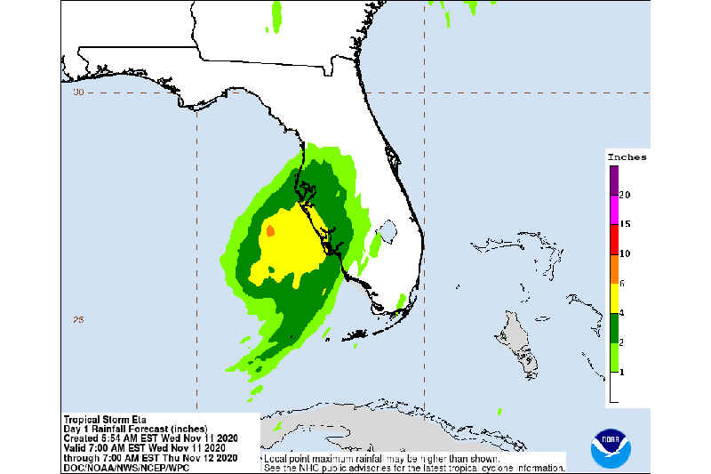
RAINFALL: Eta is expected to produce the following rainfall totals:
Western Cuba: an additional 1 to 3 inches (25 to 75 mm) on Wednesday, with isolated maximum storm total accumulations of 25 inches (765 mm).
West Florida: through Friday, 2 to 4 inches, with maximum storm total accumulations of 6 inches.
North and South Florida: an additional 1 to 2 inches, with isolated maximum storm total accumulations of 4 inches in North Florida and 20 inches in South Florida.
Flash and river flooding will be possible in western Cuba on Wednesday, along with landslides in areas of higher terrain. Additional flash and urban flooding will be possible in South Florida, especially across previously inundated areas. Flash, urban, and isolated minor river flooding is expected across portions of West and North Florida through Friday.
WIND: Hurricane conditions are possible in the watch area by early Thursday. Tropical storm conditions are expected in the Dry Tortugas through this morning. Tropical storm conditions are expected in the Tropical Storm Warning area along the Florida west coast by this afternoon. Tropical Storm conditions are possible in the watch area along the Florida Big Bend region by Thursday.
Tropical storm conditions are possible in the Tropical Storm Watch area in Cuba for the next few hours.
SURF: Swells generated by Eta are expected to affect the north coast of Cuba, southern and western Florida, and the Florida Keys during the next day or so. These swells are likely to cause life-threatening surf and rip current conditions. Please consult products from your local weather office.