
Wednesday, the heaviest rain will begin in Texas and will move east over the next 24 hours.

The southern part of that storm system has stalled and will bring heavy rains to the South with even some snow for the Carolinas

By Thursday morning, the heaviest rain will move into already flooded areas of the South from Mississippi to Alabama, where an additional 1 to 3 inches of rain is possible.

This cold blast moves into the Northeast during the day Thursday. Wind chills will bottom out Friday morning in the region with single digits possible from New York City to Boston.
Heavy rain and snow forecast across the South as Arctic blast moves to Northeast
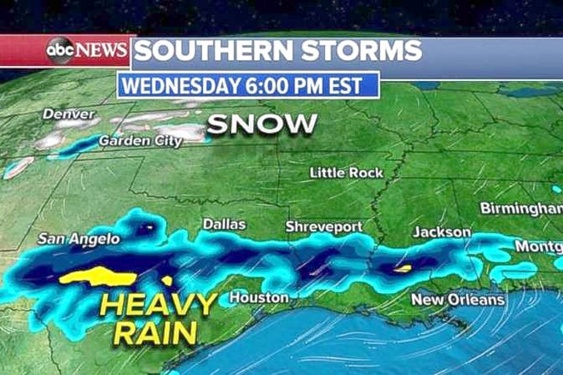
DALLAS--A storm system that moved from the Midwest to the Northeast Tuesday brought 6 to 8 inches of snow from the Great Lakes to New England and caused numerous accidents in the region. Meanwhile, the southern part of that storm system has stalled and will bring heavy rains to the South with even some snow for the Carolinas.
Wednesday, the heaviest rain will begin in Texas and will move east over the next 24 hours. To the north, snow is expected from Colorado to Kansas, where locally a half foot of snow is possible.
By Thursday morning, the heaviest rain will move into already flooded areas of the South from Mississippi to Alabama, where an additional 1 to 3 inches of rain is possible. The heaviest rain will move into the Southeast on Thursday afternoon and into the evening.
As the cold air gets wrapped to the north, snow is expected for the Carolinas Thursday afternoon and evening. Locally, 2 to 3 inches of additional rain is possible in parts of the South. Snow could also come at the worst possible time Thursday for North Carolina, as 1 to 2 inches of snow is possible during the evening commute.
Behind the storm system, watch for another cold blast for the Midwest and the Northeast starting later Wednesday. A wind chill advisory has been issued for the Upper Midwest and the Western Grea Lakes, where wind chills could dip as low as 30 degrees below zero.
This cold blast moves into the Northeast during the day Thursday. Wind chills will bottom out Friday morning in the region with single digits possible from New York City to Boston.


