
...PROLONGED PERIOD OF HAZARDOUS WEATHER EXPECTED OVER THE NORTHWESTERN BAHAMAS, FLORIDA, AND THE SOUTHEASTERN COAST OF THE UNITED STATES THIS WEEK...
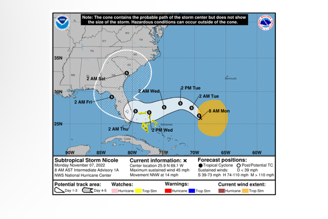
Subtropical Storm Nicole Intermediate Advisory Number 1A
NWS National Hurricane Center Miami FL AL172022
800 AM AST Mon Nov 07 2022
SUMMARY OF 800 AM AST...1200 UTC...INFORMATION
----------------------------------------------
LOCATION...25.9N 69.1W
ABOUT 520 MI...835 KM E OF THE NORTHWESTERN BAHAMAS
MAXIMUM SUSTAINED WINDS...45 MPH...75 KM/H
PRESENT MOVEMENT...NNW OR 330 DEGREES AT 14 MPH...22 KM/H
MINIMUM CENTRAL PRESSURE...1002 MB...29.58 INCHES
WATCHES AND WARNINGS
--------------------
CHANGES WITH THIS ADVISORY:
None.
SUMMARY OF WATCHES AND WARNINGS IN EFFECT:
A Tropical Storm Watch is in effect for...
* Northwestern Bahamas
 A Tropical Storm Watch means that tropical storm conditions are possible within the watch area, generally within 48 hours.
Interests in the central Bahamas, Florida, and along the southeastern coast of the United States should monitor the progress of Nicole. Additional watches will likely be required later today.
For storm information specific to your area, please monitor products issued by your national meteorological service.
DISCUSSION AND OUTLOOK
----------------------
At 800 AM AST (1200 UTC), the center of Subtropical Storm Nicole was located by NOAA Hurricane Hunters near latitude 25.9 North, longitude 69.1 West. Nicole is moving toward the north-northwest near 14 mph (22 km/h). A turn toward the northwest with a decrease in forward speed is expected later today. A westward or west-southwestward motion is forecast Tuesday through early Thursday. On the forecast track, the center of Nicole will approach the northwestern Bahamas on Tuesday, move near or over those islands on Wednesday, and approach the east coast of Florida by Wednesday night.
Maximum sustained winds are near 45 mph (75 km/h) with higher gusts. Gradual strengthening is forecast during the next few days, and Nicole could be near or at hurricane intensity by Wednesday or Wednesday night while it is moving near the northwestern Bahamas.
Winds of 40 mph or greater extend outward up to 275 miles (445 km) to the east of the center.
The estimated minimum central pressure recently measured by the NOAA Hurricane Hunters is 1002 mb (29.58 inches).
HAZARDS AFFECTING LAND
----------------------
WIND: Tropical storm conditions are possible in the northwestern Bahamas by Tuesday night or early Wednesday.
STORM SURGE: Storm surge could raise water levels by as much as 3 to 5 feet above normal tide levels along the immediate coast of the northwestern Bahamas in areas of onshore winds.
RAINFALL: Nicole is expected to produce rainfall amounts of 2 to 4 inches, with local maxima of 6 inches, across the northwestern Bahamas Tuesday through Thursday.
Heavy rainfall from this system is expected to impact portions of Florida and the southeastern United States by mid to late week.
Forecaster Papin/Brown


