
Potential Tropical Cyclone Twenty-Two
Intermediate Advisory Number 3A
NWS National Hurricane Center Miami FL AL222023
700 AM EST Fri Nov 17 2023
SUMMARY OF 700 AM EST...1200 UTC...INFORMATION
----------------------------------------------
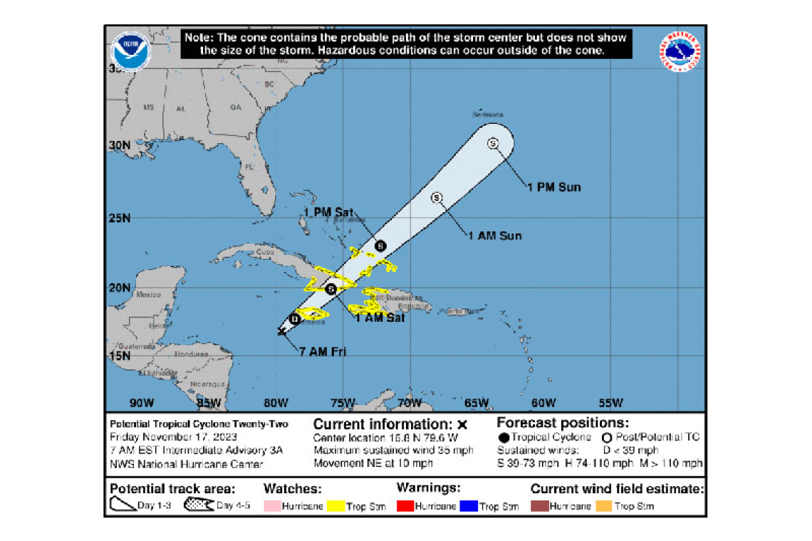
LOCATION...16.8N 79.6W
ABOUT 200 MI...325 KM WSW OF KINGSTON JAMAICA
MAXIMUM SUSTAINED WINDS...35 MPH...55 KM/H
PRESENT MOVEMENT...NE OR 40 DEGREES AT 10 MPH...17 KM/H
MINIMUM CENTRAL PRESSURE...1004 MB...29.65 INCHES
WATCHES AND WARNINGS
--------------------
CHANGES WITH THIS ADVISORY:
None.
SUMMARY OF WATCHES AND WARNINGS IN EFFECT:
A Tropical Storm Watch is in effect for...
* Jamaica
* Haiti
* Cuban provinces of Guantanamo, Santiago de Cuba, Holguin, Granma, and Las Tunas
* Southeastern Bahamas and Turks and Caicos Islands
A Tropical Storm Watch means that tropical storm conditions are possible within the watch area, generally within 48 hours.
For storm information specific to your area, please monitor products issued by your national meteorological service.
DISCUSSION AND OUTLOOK
----------------------
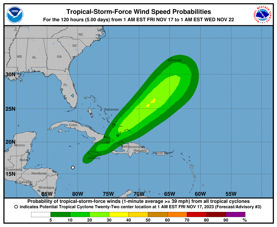
At 700 AM EST (1200 UTC), the disturbance was centered near latitude 16.8 North, longitude 79.6 West. The system is moving toward the northeast near 10 mph (17 km/h), and this motion is expected to continue with increasing forward speed through the weekend. On the forecast track, the center of the system is expected to move across Jamaica later today, southeastern Cuba by early Saturday, and the southeastern Bahamas and Turks and Caicos Islands on Saturday.
Maximum sustained winds are near 35 mph (55 km/h) with higher gusts. Some strengthening is possible during the next couple of days, and the disturbance could become a tropical storm later today or tonight.
* Formation chance through 48 hours...medium...50 percent.
* Formation chance through 7 days...medium...50 percent.
The estimated minimum central pressure is 1004 mb (29.65 inches).
HAZARDS AFFECTING LAND
----------------------
WIND: Tropical storm conditions are possible on Jamaica beginning later today, eastern Cuba and Haiti tonight, and the southeastern Bahamas and Turks and Caicos Islands on Saturday.
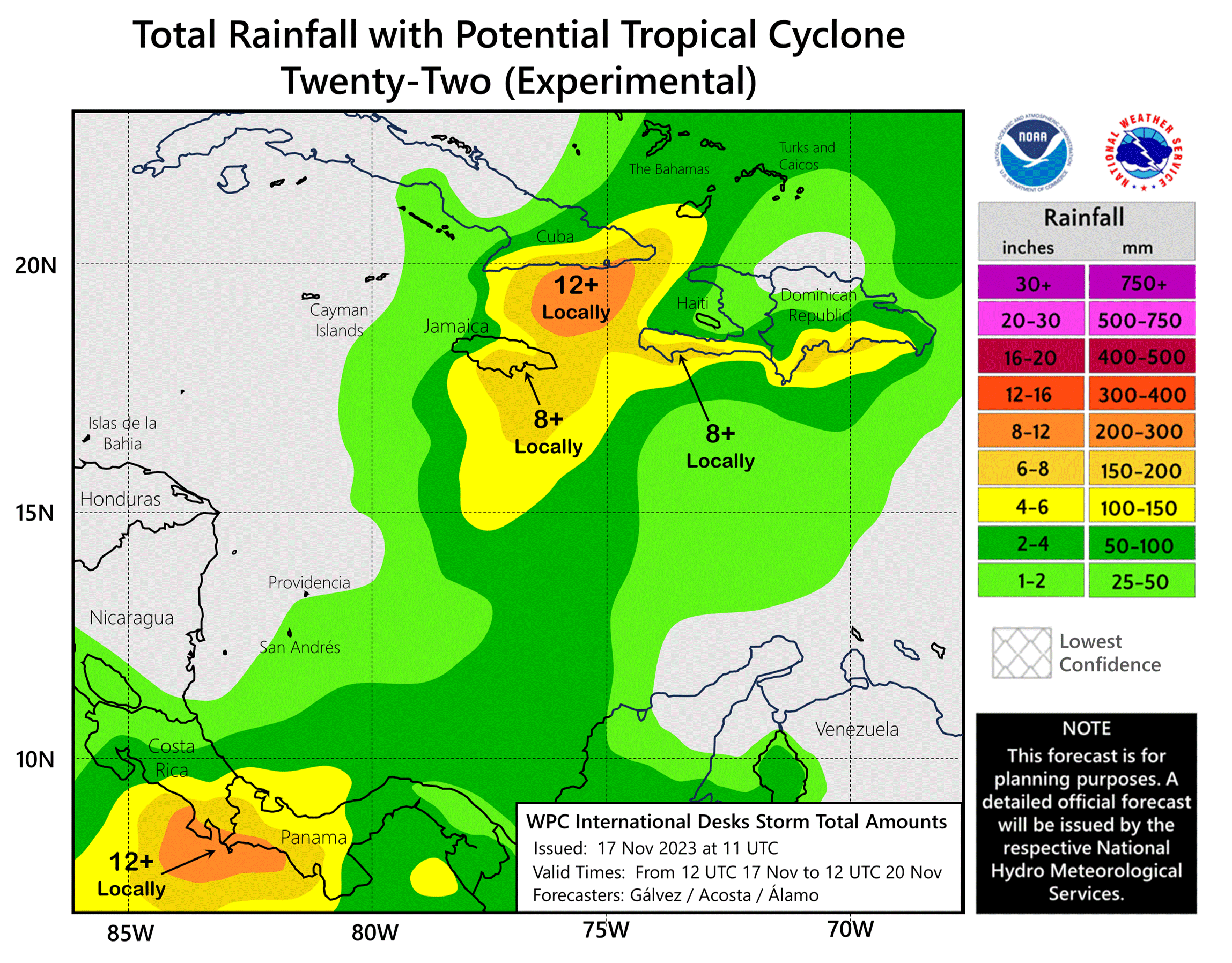
RAINFALL: Potential Tropical Cyclone Twenty-Two is expected to produce storm total rainfall of 5 to 10 inches with maximum amounts of 16 inches across portions of Panama, Costa Rica, Jamaica, southeast Cuba, and Hispaniola through Sunday morning. These rains are likely to produce flash flooding, along with mudslides in areas of higher terrain.
2 to 4 inches of rain are expected across the southeastern Bahamas and Turks and Caicos Islands through Sunday morning.
STORM SURGE: Minor coastal flooding is possible in areas of onshore winds along the southeastern coast of Cuba, the southeastern Bahamas, and the Turks and Caicos Islands.
SURF: Swells generated by the disturbance are expected to affect portions of Jamaica, Haiti, and southeastern Cuba during the next couple of days. These swells are likely to cause life-threatening surf and rip current conditions. Please consult products from your local weather office.
Forecaster Berg


