
Tropical Storm Gamma Advisory Number 9
NWS National Hurricane Center Miami FL AL252020
1000 AM CDT Sun Oct 04 2020
SUMMARY OF 1000 AM CDT...1500 UTC...INFORMATION
-----------------------------------------------
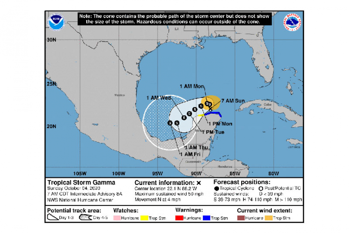
LOCATION...22.2N 88.2W
ABOUT 40 MI...65 KM N OF RIO LAGARTOS MEXICO
ABOUT 115 MI...185 KM ENE OF PROGRESO MEXICO
MAXIMUM SUSTAINED WINDS...60 MPH...95 KM/H
PRESENT MOVEMENT...N OR 360 DEGREES AT 2 MPH...4 KM/H
MINIMUM CENTRAL PRESSURE...996 MB...29.42 INCHES
WATCHES AND WARNINGS
--------------------
CHANGES WITH THIS ADVISORY:
None
SUMMARY OF WATCHES AND WARNINGS IN EFFECT:
A Tropical Storm Warning is in effect for...
* North and west of Cancun to Dzilam Mexico
A Tropical Storm Watch is in effect for...
* West of Dzilam to Progreso Mexico
A Tropical Storm Warning means that tropical storm conditions are occurring somewhere within the warning area.
A Tropical Storm Watch means that tropical storm conditions are possible within the watch area.
For storm information specific to your area, please monitor products issued by your national meteorological service.
DISCUSSION AND OUTLOOK
----------------------
At 1000 AM CDT (1500 UTC), the center of Tropical Storm Gamma was located near latitude 22.2 North, longitude 88.2 West. Gamma is moving toward the north near 2 mph (4 km/h), and this general motion with a further decrease in forward speed is expected today. Gamma should turn toward the west or west-southwest tonight or Monday, and a slow southwestward motion should continue Monday night through early Wednesday. On the forecast track, the center of Gamma will meander offshore of the northern Yucatan Peninsula and over the extreme southern Gulf of Mexico today, and pass near or just offshore of the northern coast of the Yucatan Peninsula on Monday and Tuesday.
Data from an Air Force Reserve reconnaissance aircraft indicate that the maximum sustained winds are near 60 mph (95 km/h) with higher gusts. Little change in strength is expected through this evening. Gradual weakening is anticipated to begin later tonight or on Monday and continue into Tuesday.
Tropical-storm-force winds extend outward up to 115 miles (185 km) from the center.
The latest minimum central pressure reported by Air Force Reserve reconnaissance aircraft is 996 mb (29.42 inches).
HAZARDS AFFECTING LAND
----------------------
RAINFALL: Gamma is expected to produce an additional 2 to 4 inches with isolated maximum amounts of 6 inches across portions of northern Yucatan and far western Cuba through early Tuesday. This rainfall may prolong or enhance any ongoing flash flooding.
Through the middle of the week, a separate area of significant rain is possible in the Mexican states of Campeche, Tabasco, and southeast Veracruz, with rainfall of 4 to 6 inches and isolated maximum amounts of 8 inches. This rainfall may produce life-threatening flash floods and mudslides. Another remote area of heavy rain associated with Gamma is expected to bring additional accumulations of 1 to 3 inches and isolated maximum amounts of 5 inches in southern Guatemala towards the Gulf of Fonseca region between eastern El Salvador, southern Honduras, and northwest Nicaragua.
WIND: Tropical storm conditions should continue within portions of the Tropical Storm Warning area on northern coast of the Yucatan through today. Tropical Storm conditions are possible within the Tropical Storm Watch area later today through Monday.
Forecaster Brown


