Hurricane Delta Intermediate Advisory Number 11A
NWS National Hurricane Center Miami FL AL262020
700 AM CDT Wed Oct 07 2020
SUMMARY OF 700 AM CDT...1200 UTC...INFORMATION
----------------------------------------------
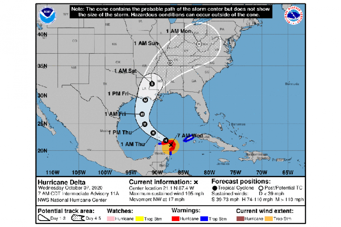
LOCATION...21.1N 87.4W
ABOUT 35 MI...55 KM W OF CANCUN MEXICO
MAXIMUM SUSTAINED WINDS...105 MPH...165 KM/H
PRESENT MOVEMENT...NW OR 305 DEGREES AT 17 MPH...28 KM/H
MINIMUM CENTRAL PRESSURE...974 MB...28.76 INCHES
WATCHES AND WARNINGS
--------------------
CHANGES WITH THIS ADVISORY:
None
SUMMARY OF WATCHES AND WARNINGS IN EFFECT:
A Hurricane Warning is in effect for...
* Tulum to Dzilam Mexico
* Cozumel
A Tropical Storm Warning is in effect for...
* Cuba province of Pinar del Rio
* Punta Herrero to Tulum Mexico
* Dzilam to Progreso Mexico
A Hurricane Warning means that hurricane conditions are expected somewhere within the warning area.
A Tropical Storm Warning means that tropical storm conditions are expected somewhere within the warning area.
Interests along the northern Gulf of Mexico coast should monitor the progress of Delta. Hurricane and Storm Surge Watches will likely be issued for a portion of this area later this morning.
For storm information specific to your area, please monitor products issued by your national meteorological service.
DISCUSSION AND OUTLOOK
----------------------
At 700 AM CDT (1200 UTC), the center of Hurricane Delta was located by satellite images and surface observation inland over northeastern Mexico near latitude 21.1 North, longitude 87.4 West. Delta is moving toward the northwest near 17 mph (28 km/h). A west-northwestward to northwestward motion is expected over the next day or so. A slower northwestward to north-northwestward motion is forecast to begin on Thursday, and a northward motion is likely Thursday night and Friday. On the forecast track, the center of Delta will move over the northeastern portion of the Yucatan Peninsula this morning. Delta is forecast to move over the southern Gulf of Mexico this afternoon, be over the southern or central Gulf of Mexico through Thursday, and approach the northern Gulf coast on Friday.
Maximum sustained winds are near 105 mph (165 km/h) with higher gusts. Although some additional weakening is likely when Delta moves over the Yucatan peninsula this morning, re-strengthening is forecast when the hurricane moves over the southern Gulf of Mexico Wednesday night and Thursday, and Delta could become a category 4 hurricane again by late Thursday. Weakening is expected as Delta approaches the northern Gulf coast on Friday.
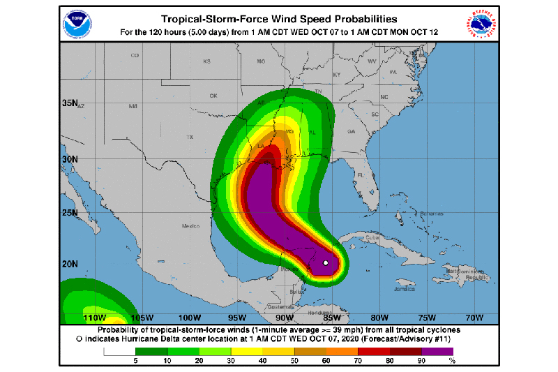
Hurricane-force winds extend outward up to 30 miles (45 km) from the center and tropical-storm-force winds extend outward up to 140 miles (220 km). A WeatherFlow observing site at Puerto Morelos, Mexico, has recently reported sustained winds of 54 mph (87 km/h) and a gust to 75 mph (122 km/h) after the passage of the center over that location. A wind gust to 64 mph (104 km/h) was recently reported on Cozumel, Mexico.
The estimated minimum central pressure based on surface observations is 974 mb (28.76 inches).
HAZARDS AFFECTING LAND
----------------------
STORM SURGE: A life-threatening storm surge will raise water levels in areas of onshore winds by as much as 6 to 9 ft above normal tide levels along the northern coast of the Yucatan Peninsula from Cabo Catoche to Progreso, and 5 to 7 ft above normal tide levels along the eastern coast of the Yucatan Peninsula from Tulum to Cabo Catoche. Near the coast, the surge will be accompanied by large and destructive waves.
WIND: In the Yucatan Peninsula, dangerous hurricane conditions are expected in portions of the warning area during the next few hours, with tropical storm conditions already occurring. Tropical storm conditions are expected in the tropical storm warning area to continue for the next several hours. In Cuba, tropical storm conditions could continue over far western portions of the island during the next few hours.
RAINFALL: Through early Thursday, Delta is expected to produce 4 to 6 inches of rain, with isolated maximum totals of 10 inches, across portions of the northern Yucatan Peninsula. This rainfall may result in areas of significant flash flooding. In addition, 2 to 4 inches of rain, with isolated higher amounts, are expected across portions of western Cuba. This rainfall may result in areas of flash flooding and mudslides.
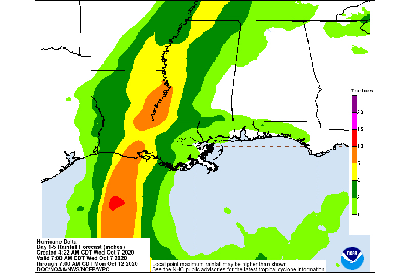
Friday through Saturday, Delta is expected to produce 4 to 8 inches of rain, with isolated maximum totals of 12 inches across portions of the central Gulf Coast north into portions of the Lower Mississippi Valley. These rainfall amounts will lead to flash, urban, and small stream flooding, along with minor river flooding. Heavy rainfall will eventually spread into the Tennessee Valley, and interior southeastern United States this weekend into early next week.
SURF: Swells generated by Delta will affect land areas around the northwestern Caribbean Sea for the next day or so. These swells are likely to cause life-threatening surf and rip current conditions.