
...FURTHER WEAKENING EXPECTED...
Tropical Storm Gamma Intermediate Advisory Number 12A
NWS National Hurricane Center Miami FL AL252020
700 AM CDT Mon Oct 05 2020
SUMMARY OF 700 AM CDT...1200 UTC...INFORMATION
----------------------------------------------
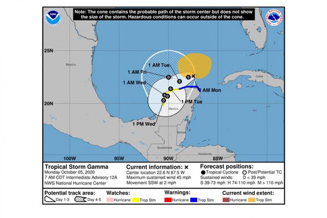
LOCATION...22.6N 87.5W
ABOUT 165 MI...270 KM ENE OF PROGRESO MEXICO
ABOUT 150 MI...240 KM NNW OF COZUMEL MEXICO
MAXIMUM SUSTAINED WINDS...45 MPH...75 KM/H
PRESENT MOVEMENT...SSW OR 205 DEGREES AT 2 MPH...4 KM/H
MINIMUM CENTRAL PRESSURE...1001 MB...29.56 INCHES
WATCHES AND WARNINGS
--------------------
CHANGES WITH THIS ADVISORY:
None.
SUMMARY OF WATCHES AND WARNINGS IN EFFECT:

A Tropical Storm Warning is in effect for...
* North and west of Cancun to Dzilam Mexico
A Tropical Storm Watch is in effect for...
* West of Dzilam to Campeche Mexico
A Tropical Storm Warning means that tropical storm conditions are occurring somewhere within the warning area.
A Tropical Storm Watch means that tropical storm conditions are possible within the watch area.
For storm information specific to your area, please monitor products issued by your national meteorological service.
DISCUSSION AND OUTLOOK
----------------------
At 700 AM CDT (1200 UTC), the center of Tropical Storm Gamma was located near latitude 22.6 North, longitude 87.5 West. Gamma is drifting toward the south-southwest near 2 mph (4 km/h). Gamma is forecast to gradually turn toward the southwest later today, and continue to move slowly in that direction through mid-week. On the forecast track, the center of Gamma will continue to meander offshore of the northern Yucatan Peninsula and pass near or just offshore of the northern coast of the Yucatan Peninsula this evening and on Tuesday. Gamma could possibly move inland along the northwest coast of the Yucatan Peninsula Tuesday night and Wednesday.
Data from the reconnaissance aircraft indicate that maximum sustained winds have decreased to near 45 mph (75 km/h) with higher gusts. Gradual weakening is forecast during the next few days.
Tropical-storm-force winds extend outward up to 160 miles (260 km), mainly northwest through northeast of the center.
The estimated minimum central pressure based on measurements from the hurricane hunter plane is 1001 mb (29.56 inches).
HAZARDS AFFECTING LAND
----------------------
RAINFALL: Through midweek, Gamma is expected to produce an additional 3 to 6 inches of rainfall with isolated maximum amounts of 8 inches across portions of the Mexican states of Yucatan, Campeche, and Tabasco. This rainfall may produce significant flash flooding.
WIND: Tropical storm conditions are likely in portions of the Tropical Storm Warning area along the northern coast of the Yucatan Peninsula later today. Tropical Storm conditions are possible within the Tropical Storm Watch area tonight and on Tuesday.
Forecaster Roberts


