
...HEAVY RAINFALL AND FLOODING LIKELY OVER MUCH OF THE LESSER ANTILLES...
Hurricane Tammy Advisory Number 9
NWS National Hurricane Center Miami FL AL202023
1100 AM AST Fri Oct 20 2023
SUMMARY OF 1100 AM AST...1500 UTC...INFORMATION
-----------------------------------------------
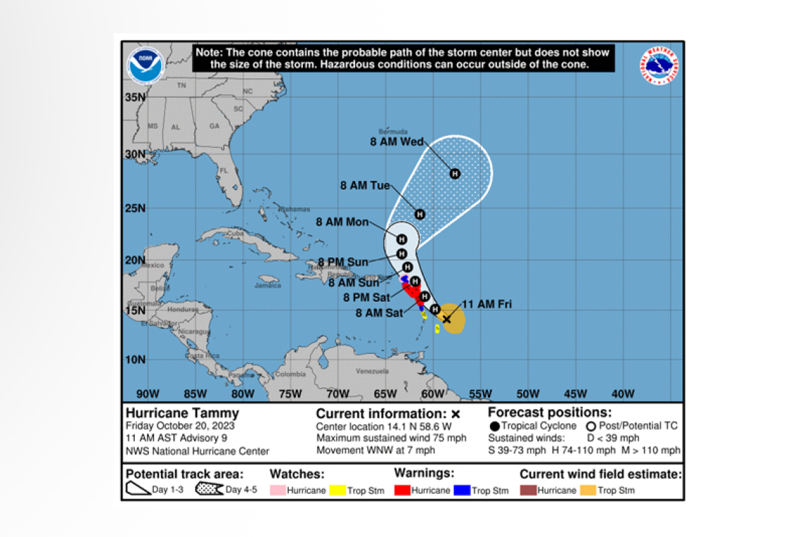
LOCATION...14.1N 58.6W
ABOUT 165 MI...265 KM ESE OF MARTINIQUE
ABOUT 240 MI...385 KM SE OF GUADELOUPE
MAXIMUM SUSTAINED WINDS...75 MPH...120 KM/H
PRESENT MOVEMENT...WNW OR 290 DEGREES AT 7 MPH...11 KM/H
MINIMUM CENTRAL PRESSURE...992 MB...29.30 INCHES
WATCHES AND WARNINGS
--------------------
CHANGES WITH THIS ADVISORY:
The government of France has issued a Hurricane Warning for Guadeloupe.
The government of Antigua has issued a Hurricane Warning for Antigua, Barbuda, Montserrat, and St. Kitts and Nevis.
SUMMARY OF WATCHES AND WARNINGS IN EFFECT:
A Hurricane Warning is in effect for...
* Guadeloupe
* Antigua, Barbuda, Montserrat, St. Kitts and Nevis
A Hurricane Watch is in effect for...
* Anguilla
* St. Maarten
* St. Martin and St. Barthelemy
A Tropical Storm Warning is in effect for...
* Dominica
* Anguilla
* St. Maarten
* St. Martin and St. Barthelemy
* Saba and St. Eustatius
A Tropical Storm Watch is in effect for...
* Barbados
* Martinique
A Hurricane Watch means that hurricane conditions are possible within the watch area, in this case within the next 24 to 36 hours.
A Tropical Storm Warning means that tropical storm conditions are expected somewhere within the warning area within 36 hours.
A Tropical Storm Watch means that tropical storm conditions are possible within the watch area, generally within 48 hours.
Additional watches and warnings could be required later today.
For storm information specific to your area, please monitor products issued by your national meteor-ological service.
DISCUSSION AND OUTLOOK
----------------------
At 1100 AM AST (1500 UTC), the center of Hurricane Tammy was located near latitude 14.1 North, longitude 58.6 West. Tammy is moving toward the west-northwest near 7 mph (11 km/h), and this general motion is expected to continue through this afternoon. A turn toward the northwest is antic-ipated by this evening, followed by a north-northwestward and northward turn Saturday night through Sunday night. On the forecast track, the center of Tammy will move near or over portions of the Leeward Islands tonight and on Saturday, and then move north of the northern Leeward Islands on Sunday.
Data from NOAA and Air Force Reserve reconnaissance aircraft indicate that the maximum sustained winds are near 75 mph (120 km/h) with higher gusts. Gradual strengthening is forecast during the next couple of days, and Tammy is expected to be a hurricane while it moves near or over portions of the Leeward Islands.
Hurricane-force winds extend outward up to 25 miles (35 km) from the center and tropi-cal-storm-force winds extend outward up to 140 miles (220 km).
The minimum central pressure estimated from reconnaissance aircraft data is 992 mb (29.30 inch-es).
HAZARDS AFFECTING LAND
----------------------
WIND: Tropical storm conditions are expected within the tropical storm warning area beginning lat-er today or tonight. Hurricane conditions are expected in the hurricane warning area by late tonight or early Saturday. Hurricane conditions are possible in the hurricane watch area in the Leeward Is-lands on Saturday. Tropical storm conditions are possible within the tropical storm watch area begin-ning latertoday.
RAINFALL: Tammy is expected to produce the following storm total rainfall:
Leeward Islands: 4 to 8 inches with maximum amounts of 12 inches
Northern Windward Islands: 2 to 4 inches with maximum amounts of 6 inches
British and U.S. Virgin Islands into eastern Puerto Rico: 1 to 2 inches with maximum amounts of 4 inches.
These rains may produce isolated flash and urban flooding, along with isolated mudslides in areas of higher terrain.
STORM SURGE: Storm surge could raise water levels by as much as 1 to 3 feet above normal tide lev-els near where the center of Tammy moves across the Leeward Islands. Near the coast, the surge will be accompanied by large and dangerous waves.
SURF: Swells generated by Tammy will continue to affect portions of the Lesser Antilles during the next few days. These swells are likely to cause life-threatening surf and rip current conditions. Please consult products from your local weather office.
Forecaster Brown


