
DATE ISSUED: Monday, October 02, 2023 @ 12:00 LST (16:00 UTC)
VALID UNTIL: Tuesday midday (12:00 LST) October 03, 2023
…A SMALL CRAFT ADVISORY REMAINS IN EFFECT FOR ST. MAARTEN UNTIL FURTHER NOTICE…
WEATHER:
This afternoon: Partly cloudy, becoming cloudy at times with isolated showers.
Tonight through Tuesday midday: Generally cloudy with scattered showers and isolated thunderstorms.
Forecast High: 32°C / 90°F
Forecast Low: 27°C / 81°F
Sunset Today: 6:00 P.M.
Sunrise Tomorrow: 6:03 A.M.
SURFACE WINDS: This afternoon through Tuesday midday: North-northerly with a gentle to moderate breeze of 08 to 16 mph, and possibly higher gusts in or near showers.
SYNOPSIS:
A combination of abundant moisture and instability associated with Tropical Storm Philippe will produce cloudy periods, showers, and possible isolated thunderstorms throughout the forecast period. Some of these showers may be heavy and could lead to flooding and/or rock-slides. Therefore, residents and visitors of vulnerable and flood-prone areas are advised to use precautions.
Rough seas, peaking up to 8 feet are expected for the next few days. Small craft operators and swimmers should continue to exercise caution.
STATE OF THE SEA: Moderate to rough
WAVES/SWELLS: 6 to 8 feet
SPECIAL FEATURE:
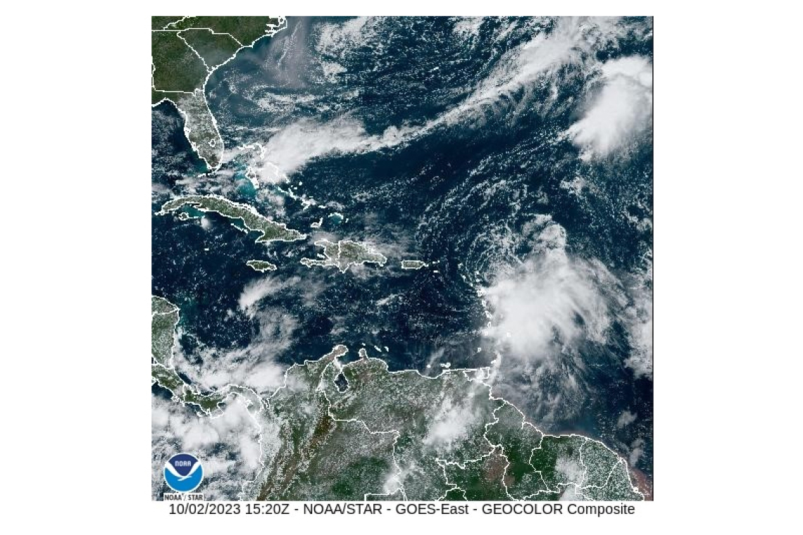
At 11:00 am, the center of Tropical Storm Philippe was located approximately 17.1 North 60.7 West or about 90 miles east-southeast of St. Maarten. Philippe is moving towards the west-northwest at 7 mph (11 km/h), with maximum sustained winds of 50 mph (85 km/h) and higher gusts.Based on the current track, Philippe’s closest point to St. Maarten is expected to be approximately 120 miles northeast early Tuesday morning. A Flood Watch or Warning may be issued for St. Maarten later today.
The Meteorological Department St. Maarten will continue to monitor the progress of this system and update the public accordingly.
OUTLOOK through Wednesday midday: Partly cloudy to cloudy with isolated showers and possible isolated thunderstorms.
FORECASTER: Connor
3-DAY FORECAST
|
DAY |
Monday |
Tuesday |
Wednesday |
|
WEATHER |
Partly Cloudy/Cloudy, Isolated Showers,poss. Thunderstorms |
Cloudy, Scattered Showers, Isolated Thunderstorms |
Partly Cloudy/Cloudy, Isolated Showers,poss. Thunderstorms |
|
HIGH TEMP |
32°C / 90°F |
32°C / 90°F |
33°C / 91°F |
|
LOW TEMP |
27°C / 81°F |
27°C / 81°F |
28°C / 82°F |
|
SUNRISE |
06:03 AM |
06:03 AM |
06:03 AM |
|
SUNSET |
06:00 PM |
05:59 PM |
05:59 PM |


