
DATE ISSUED: Friday, September 08, 2023 @ 12:00 LST (16:00 UTC)
VALID UNTIL: Saturday midday (12:00 LST) September 09, 2023
…A HIGH SURF ADVISORY IS IN EFFECT UNTIL FURTHER NOTICE…
…A SMALL CRAFT ADVISORY IS IN EFFECT UNTIL FURTHER NOTICE…
…LEE CAUSING HAZARDOUS SEAS…
WEATHER:
This afternoon through Saturday midday: Partly cloudy, becoming cloudy at times with isolated showers and possible thunder.
Forecast High: 32°C / 90°F
Forecast Low: 27°C / 81°F
Sunset Today: 6:21 P.M.
Sunrise Tomorrow: 5:59 A.M.
SURFACE WINDS: This afternoon through Saturday midday: Northeasterly to northerly with a light to gentle breeze of 05 to 12 mph, with possible higher gusts in or near showers.
SYNOPSIS:
Increasing moisture and instability associated with the proximity of Hurricane Lee will produce isolated showers and possible thunderstorms across the local area.
Rough seas up to 10 feet and northerly swells generated by Lee are expected to affect regional waters throughout the weekend. Sea bathers should avoid swimming, and small craft operators should exercise extreme caution to guard against loss of life and/or property damage. Beach erosion will also be of concern, particularly along the eastern and northern shores of the island.
STATE OF THE SEA: Moderate to rough
WAVES/SWELLS: 6 to 10 feet
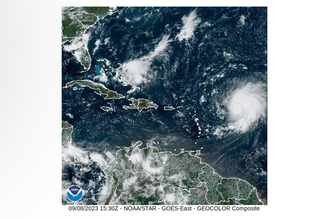
SPECIAL FEATURE:
At 11am, the center of Major Hurricane Lee was located approximately 565 miles east of St. Maarten. Maximum sustained winds decreased to near 155 mph (250 km/h) with higher gusts. Fluctuations in intensity are likely over the next few days. Movement is toward the west-northwest near 13 mph (20 km/h).
Tropical Storm force winds extend outward up to 140 miles (220 km) and Hurricane force winds extend outward up to 35 miles (55 km) from the center.
On the forecast track, the center of Hurricane Lee is predicted to be at its closest point to St. Maarten 280 miles north-northeast on Sunday.
Residents and visitors are urged to remain vigilant and monitor all subsequent updates.
The Meteorological Department St. Maarten will continue to monitor the progress of this system and update the public accordingly.
OUTLOOK through Sunday midday: Partly cloudy to cloudy with isolated showers and a chance of isolated thunderstorms.
FORECASTER: Connor
3-DAY FORECAST
|
DAY |
Friday |
Saturday |
Sunday |
|
WEATHER |
Partly Cloudy/Cloudy, Isolated Showers, possible Thunder |
Partly Cloudy/Cloudy, Isolated Showers,Isol. Thunderstorms |
Partly Cloudy/Cloudy, Isolated Showers, possible Thunder |
|
HIGH TEMP |
32°C / 90°F |
32°C / 90°F |
32°C / 90°F |
|
LOW TEMP |
27°C / 81°F |
26°C / 79°F |
26°C / 79°F |
|
SUNRISE |
05:59 AM |
05:59 AM |
06:00 AM |
|
SUNSET |
06:21 PM |
06:20 PM |
06:19 PM |


