
...EXPECTED TO PASS VERY NEAR THE NORTHERN LEEWARD ISLANDS LATE THURSDAY AND THURSDAY NIGHT...
Tropical Storm Jerry Advisory Number 5
NWS National Hurricane Center Miami FL AL102025
1100 AM AST Wed Oct 08 2025
SUMMARY OF 1100 AM AST...1500 UTC...INFORMATION
-----------------------------------------------
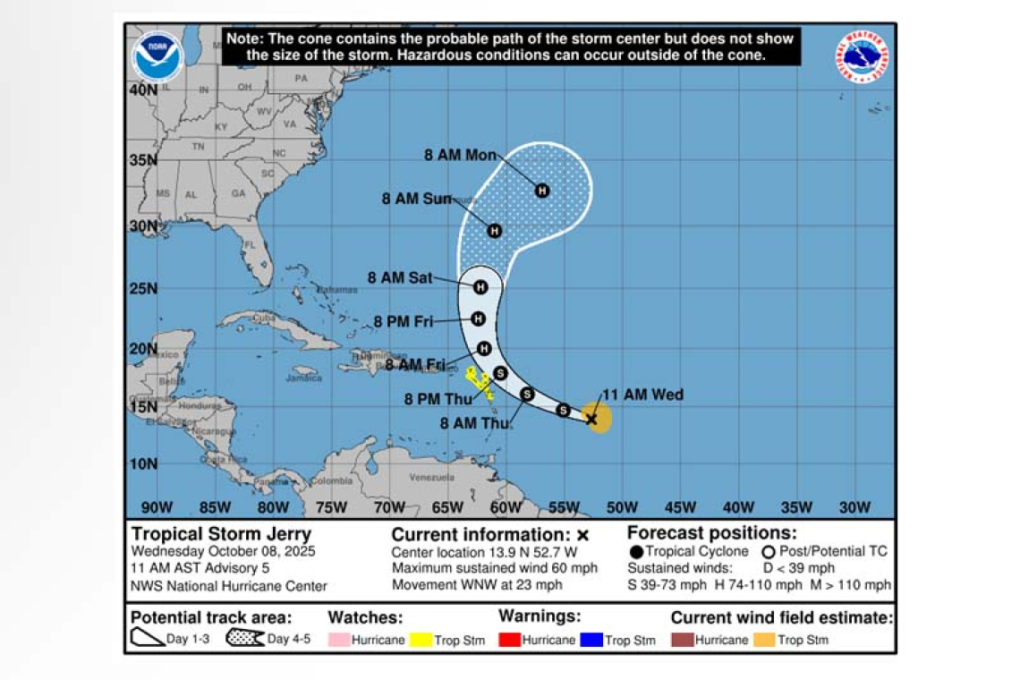
LOCATION...13.9N 52.7W
ABOUT 750 MI...1210 KM ESE OF THE NORTHERN LEEWARD ISLANDS
MAXIMUM SUSTAINED WINDS...60 MPH...95 KM/H
PRESENT MOVEMENT...WNW OR 290 DEGREES AT 23 MPH...37 KM/H
MINIMUM CENTRAL PRESSURE...1003 MB...29.62 INCHES
WATCHES AND WARNINGS
--------------------
 CHANGES WITH THIS ADVISORY:
None.
SUMMARY OF WATCHES AND WARNINGS IN EFFECT:
A Tropical Storm Watch is in effect for...
* Antigua, Barbuda, and Anguilla
* St. Kitts, Nevis, and Montserrat
* St. Barthelemy and St. Martin
* Sint Maarten
* Saba and St. Eustatius
* Guadeloupe and the adjacent islands
Interests elsewhere in the northern Leeward Islands and the British and U.S. Virgin Islands should monitor the progress of Jerry.
For storm information specific to your area, please monitor products issued by your national meteor-ological service.
DISCUSSION AND OUTLOOK
----------------------
At 1100 AM AST (1500 UTC), the center of Tropical Storm Jerry was located near latitude 13.9 North,
longitude 52.7 West. Jerry is moving toward the west-northwest near 23 mph (37 km/h), and this general motion is expected to continue through early Thursday. A turn toward the northwest and then north at a slower forward speed is expected late Thursday into Saturday. On the forecast track, the center of Jerry is expected to pass near or to the northeast of the northern Leeward Islands late Thursday and Thursday night.
Data from a NOAA Hurricane Hunter aircraft indicate that maximum sustained winds have increased to near 60 mph (95 km/h) with higher gusts. Gradual strengthening is forecast during the next few days, and Jerry could become a hurricane by the weekend.
Tropical-storm-force winds extend outward up to 125 miles (205 km) from the center.
The estimated minimum central pressure is 1003 mb (29.62 inches).
HAZARDS AFFECTING LAND
----------------------
WIND: Tropical storm conditions are possible in portions of the northern Leeward Islands within the watch area late Thursday into Friday.
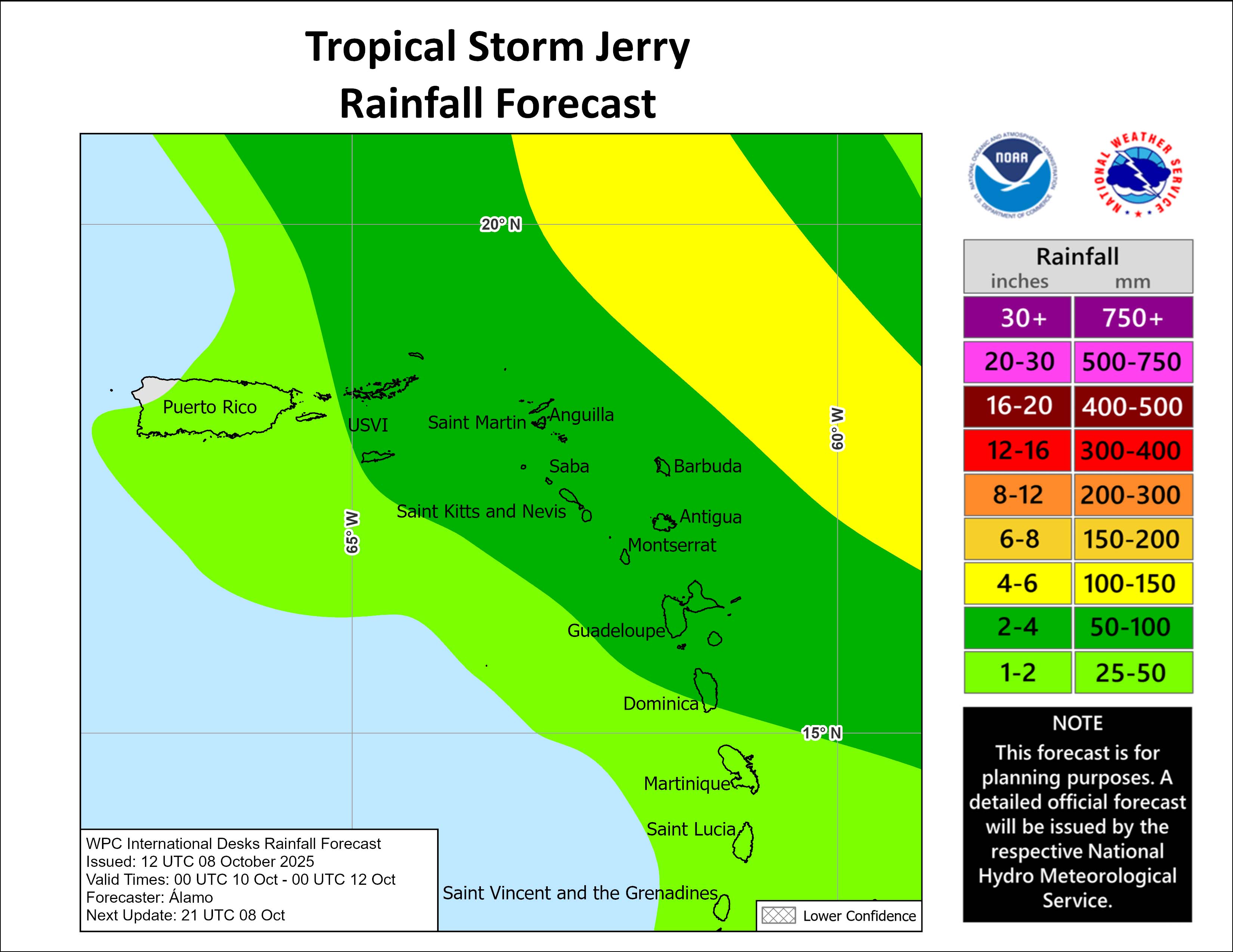
RAINFALL: On Thursday into early Friday, 2 to 4 inches of rain with local storm total maxima to 6 inches are expected across the Leeward Islands, British Virgin Islands, and U.S. Virgin Islands from Thursday into Saturday morning due to Jerry. This rainfall brings a risk of flash flooding, especially in areas of steep terrain.
SURF: Swells generated by Jerry are expected to reach the Leeward and Windward Islands on Thurs-day, then spread westward toward the Greater Antilles on Friday. These swells are likely to cause life-threatening surf and rip current conditions. Please consult products from your local weather of-fice.
Forecaster Berg


