
...EXPECTED TO PASS NEAR OR NORTH OF THE LEEWARD ISLANDS ON SATURDAY...
Hurricane Erin Advisory Number 17
NWS National Hurricane Center Miami FL AL052025
1100 AM AST Fri Aug 15 2025
SUMMARY OF 1100 AM AST...1500 UTC...INFORMATION
-----------------------------------------------
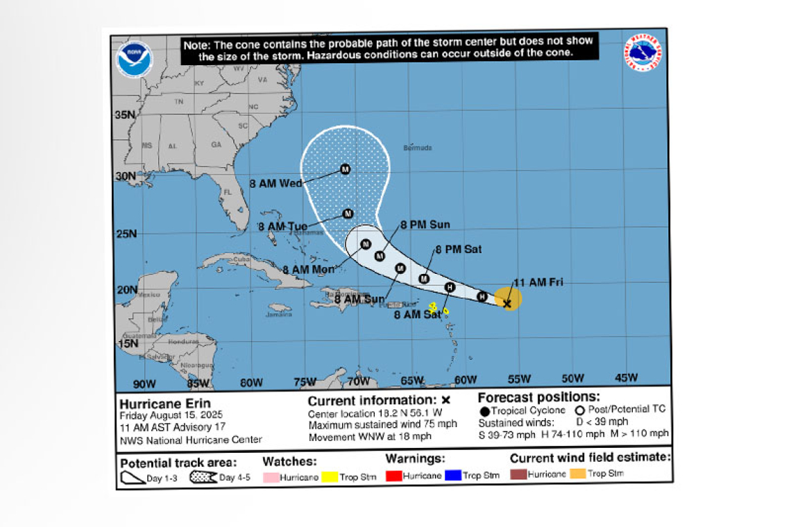
 LOCATION...18.2N 56.1W
ABOUT 460 MI...740 KM E OF THE NORTHERN LEEWARD ISLANDS
MAXIMUM SUSTAINED WINDS...75 MPH...120 KM/H
PRESENT MOVEMENT...WNW OR 290 DEGREES AT 18 MPH...30 KM/H
MINIMUM CENTRAL PRESSURE...996 MB...29.42 INCHES
WATCHES AND WARNINGS
--------------------
CHANGES WITH THIS ADVISORY:
None.
SUMMARY OF WATCHES AND WARNINGS IN EFFECT:
A Tropical Storm Watch is in effect for...
* Anguilla and Barbuda
* St. Martin and St. Barthelemy
* Saba and St. Eustatius
* Sint Maarten
A Tropical Storm Watch means that tropical storm conditions are possible within the watch area, generally within 48 hours.
Interests elsewhere in the northern Leeward Islands, Virgin Islands, and Puerto Rico should monitor the progress of Erin.
For storm information specific to your area, please monitor products issued by your national meteor-ological service.
DISCUSSION AND OUTLOOK
----------------------
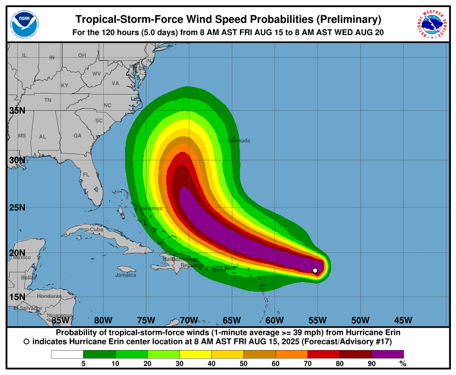
 At 1100 AM AST (1500 UTC), the center of Hurricane Erin was located near latitude 18.2 North, longi-tude 56.1 West. Erin is moving toward the west-northwest near 18 mph (30 km/h). This motion is ex-pected to continue into the weekend. On the forecast track, the center of Erin is likely to move near or just north of the northern Leeward Islands over the weekend.
Reports from NOAA and Air Force Reserve Hurricane Hunter aircraft indicate that maximum sustained winds have increased to near 75 mph (120 km/h) with higher gusts. Steady to rapid strengthening is expected during the next two to three days, and Erin is forecast to become a major hurricane during the weekend.
Hurricane-force winds extend outward up to 25 miles (35 km) from the center and tropi-cal-storm-force winds extend outward up to 115 miles (185 km) mainly to the north of the center .
The latest minimum central pressure reported by the NOAA and Air Force Hurricane Hunter aircraft is 996 mb (29.42 inches).
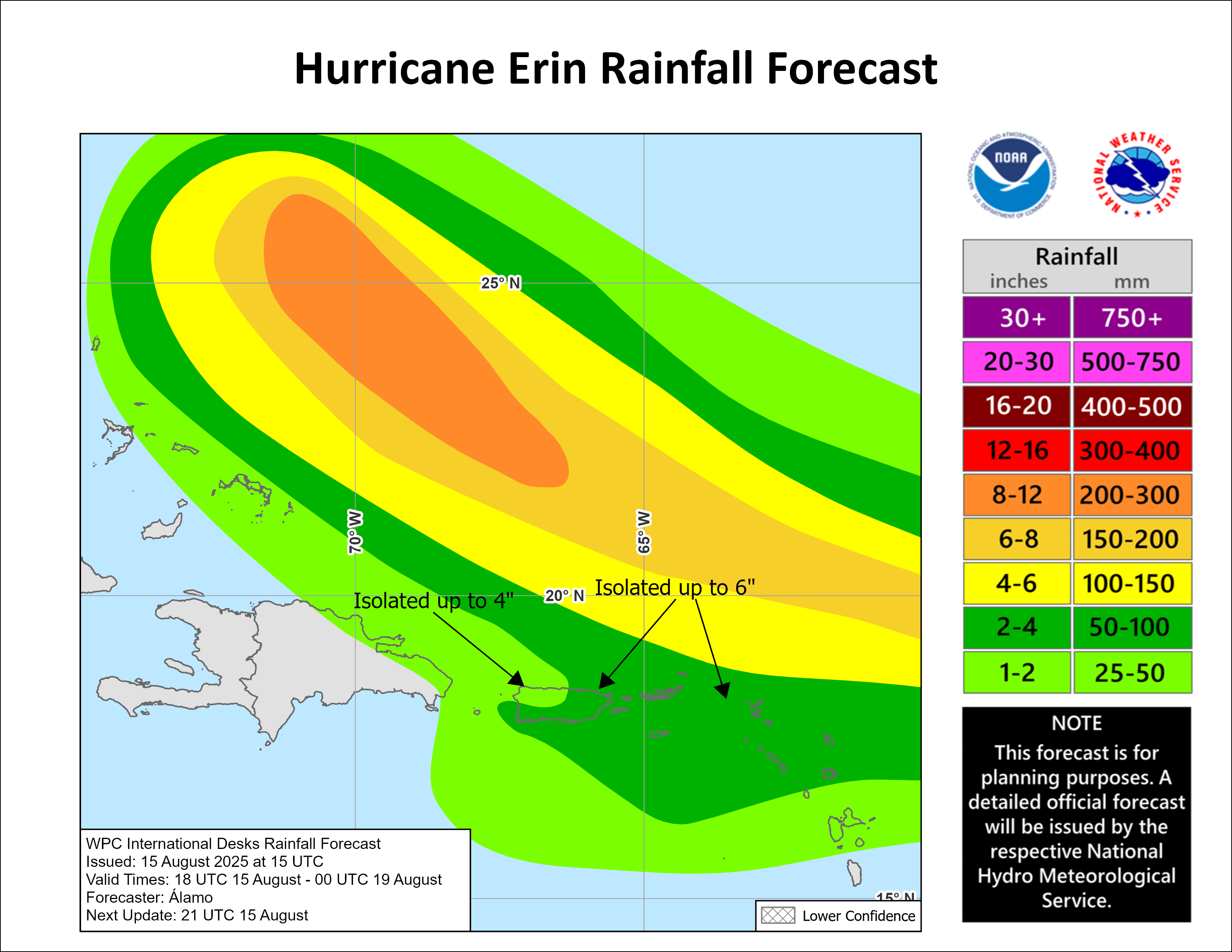
RAINFALL: The outer bands of Erin are expected to produce areas of heavy rainfall tonight into Sunday across the northern Leeward Islands, the Virgin Islands, and Puerto Rico. Rainfall totals of 2 to 4 inch-es, with isolated totals of 6 inches, are expected. This rainfall may lead to isolated and locally consid-erable flash and urban flooding, along with landslides or mudslides.
WIND: Tropical storm conditions are possible within the watch area by early Saturday.
SURF: Swells generated by Erin will begin affecting portions of the northern Leeward Islands, the Vir-gin Islands and Puerto Rico by this weekend, and will likely spread to the western Atlantic next week. These swells are likely to cause life-threatening surf and rip current conditions. Please consult prod-ucts from your local weather forecast office.
Forecaster Beve


